
Last Updated on May 22, 2026 by Megan Rynearson
What do a nuclear bunker, the world’s largest steerable radio telescope, and abandoned coal mines have in common? They all belong to the wild and wonderful state of West Virginia!
I was able to visit West Virginia on a road trip during the week of labor day, and it totally blew my expectations out of the water. There are so many underrated places to explore, scenic hikes to do, and it’s home to the newest US National Park, New River Gorge!
Even John Denver couldn’t fully prepare me for the amazing-ness West Virginia has to offer.
If you’re looking for the perfect 7-day West Virginia road trip itinerary, look no further than this adventure through the Appalachians!
How to Get to West Virginia
West Virginia is a state best experienced by driving. There aren’t any major airports, but American, Delta, and United airlines fly into Yeager International Airport located in Charleston. Pittsburgh, Cincinnati, and Columbus are relatively close as well.
Flights can be quite expensive though, so I’d definitely recommend driving if you’re only a few states away.
Plus, who doesn’t love a good road trip through some country roads?
When is the Best Time to Visit West Virginia?
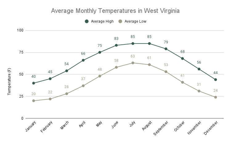
The best time to visit West Virginia is late spring or early fall (typically called “shoulder season”). Even though it has a pretty mild climate, May – July are the busiest months, so you’ll find more expensive hotel prices and more crowds during the summer.
We personally used the week of labor day to do this trip, and I would highly recommend it. You don’t quite get the fall colors yet, but you can get a full week trip for the price of 4 vacation days instead of 5.
There weren’t many crowds and the weather was comfortable in early September!
Related: The Ultimate Red River Gorge Weekend Itinerary
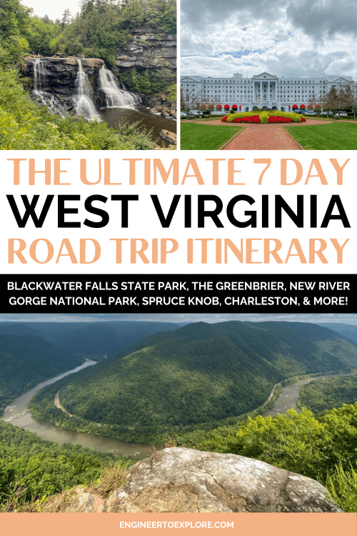
The Ultimate 7-Day West Virginia Road Trip Itinerary
Here’s a map of the West Virginia road trip route you’ll be taking through the Appalachians.
You’ll cover over 330 miles in 7.5 hours of driving throughout the week, not including getting to and from the starting and ending destinations.
This itinerary can be done in either direction!

Day 0: Drive to West Virginia
The purpose of day 0 of your West Virginia road trip is to simply get there. Since we were coming from southern Indiana, the western border of West Virginia was a good 5 hours away.
We stayed in Parkersburg, but feel free to stay anywhere that gets you within a few hours of your next destination, Blackwater State Park (or just drive the entire way there).
We left after work on Friday, so we didn’t get into Parkersburg until late.
Day 1: Blackwater Falls State Park
Total driving distance: 175 miles / 3.5 hours (from Parkersburg)
Get ready for day 1 of your West Virginia road trip! Grab breakfast on the road or at your hotel and make your way to Blackwater Falls State Park.
On your way to the falls, stop for lunch and a coffee in Thomas, WV (about 3 hours from Parkersburg, right outside the entrance of Blackwater Falls).
Thomas is a teeny former coal town situated on the north fork of the Blackwater River. With a population of only 600, it has some great shops and restaurants to explore and stretch your legs.
Eat lunch at Farm Up Table, or one of the other restaurants in the historic district.
Hike Pase Point Trail
Length: 3.8 miles
Elevation gain: 377 feet
Type: Out and back
Difficulty: Easy
Time: 1.5 hours
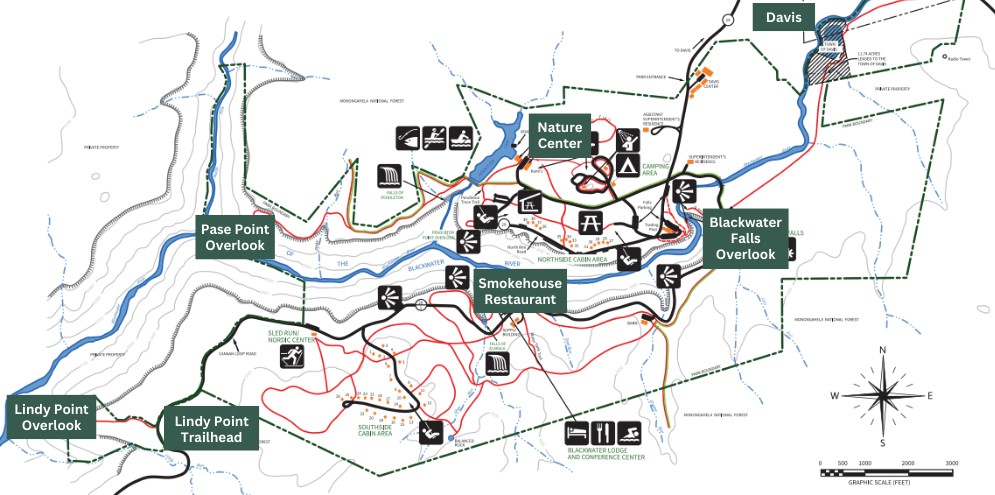
There is no entrance fee to enter Blackwater Falls State Park. A full map of the area can be found here and I’ve pointed out all the places I talk about in the image below.
If you’re up for a hike to stretch your legs after being in the car for a couple of days, look no further than the Pase Point Trail. You’ll want to wear hiking shoes on this trail, as it can get muddy in some places and isn’t paved.
The Pase Point trailhead starts at the Nature Center (there was plenty of parking here) and crosses Pendleton Creek where you can get a great view of the Pendleton Lake. You’ll wind through a forest of rhododendron (the state flower of West Virginia) and walk along the Blackwater River Gorge.
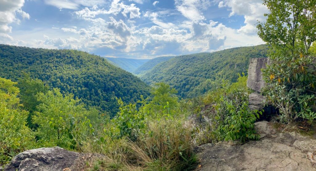
You won’t be able to see the gorge since the forest is so thick, but you’ll wind up at Pase Point Overlook. This is the gorge where the North Fork feeds the Blackwater River and the views are incredible!
We did this hike at 3:30 pm on the Saturday before Labor Day and we only saw a handful of people, so it’s also likely you’ll have the trail to yourself.
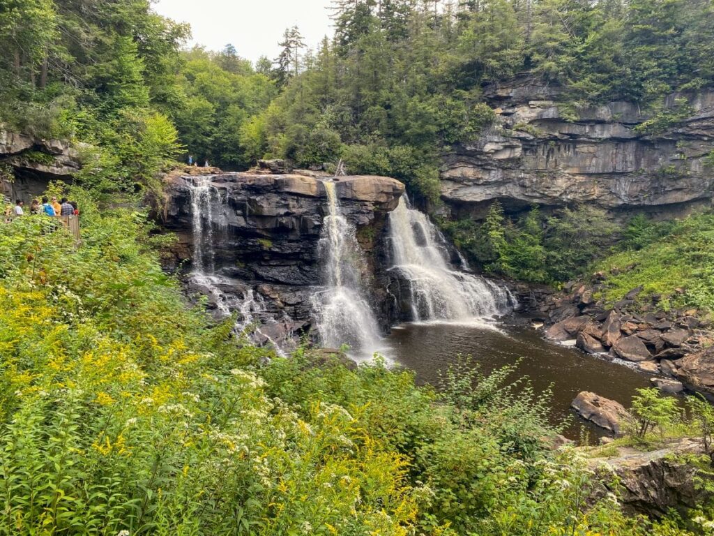
View the Blackwater Falls Overlook
Once you make it to Blackwater Falls State Park, you can’t miss seeing the waterfall!
I’d recommend parking in one of the further lots from the falls, as the closer ones can fill up quickly. You’ll have a slightly further walk to the official trailhead, but the short walk is worth it to be able to park quickly.
Once you reach the boardwalk, you’ll walk down about 200 steps to view the falls. The water drops 62-ft and then winds through the 8-mile Blackwater River Gorge. The falls get their amber and black colors due to tannic acid from the fallen hemlock and red spruce needles.
There were some crowds when we were here in the late afternoon, but it wasn’t too bad for a holiday weekend.
View the Lindy Point Overlook at Sunset (Optional)
If you’re not too tired and are up for one more adventure in Blackwater Falls, follow Canaan Loop road southwest until you get to the Lindy Point Overlook Trailhead.
There is a short, 0.4 mile hike (no elevation gain) to the overlook where you’ll see panoramic views of the Blackwater River Canyon. Stay for sunset for the best views in the entire park!
If you’re hungry, grab dinner at the Smokehouse at Blackwater Falls on the way to Lindy Point Overlook. I personally haven’t eaten here, but it’s the only restaurant in the park so you can’t beat the convenience.
Drive to Seneca Rocks
After your hike at Blackwater Falls, jump back in the car and drive 40 minutes to your accommodations in Seneca Rocks.
Seneca Rocks is a very small town and doesn’t have much in the way of restaurants and hotels.
Yokum’s General Store is the only place to grab supplies, so I’d recommend stocking up on anything specific in Davis ahead of time. They have trail snacks, a small produce selection, and other basic essentials at the general store, though.
There is also a restaurant at the general store (the food isn’t bad, but it’s nothing amazing either, so set your expectations accordingly).
Where to Stay in Seneca Rocks
There are no chain hotels in Seneca Rocks, so renting a cabin or camping are your best options.
Yokum’s Vacationland: Motel, cabins, and campground within walking distance to Seneca Rocks. There is a general store and restaurant as well (really your only option for food and supplies in the area).
Spruce Mountain Cabins: Reasonably priced cabins for 2-4 people located all throughout the area. We stayed in this one and had an amazing view of the mountains!
Smoke Hole Resort: Rustic cabins with lots of options for couples, families, and camping. Located 15 minutes north of Seneca Rocks.
Settle in, because you’ll be staying here for the next 2 nights!
Day 2: Seneca Rocks and Spruce Knob
Total driving distance: 50 miles / 1.5 hours
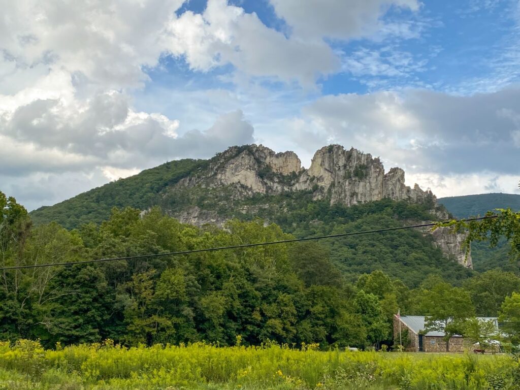
Grab a quick breakfast at Yokum’s and fuel up before hiking the Seneca Rocks Trail. Seneca Rocks is a popular rock climbing destination and West Virginia’s best-known landmark.
Hike the Seneca Rocks Trail
Length: 3.5 miles
Elevation gain: 807 ft
Type: Out and back
Difficulty: Moderate
Time: 1.5 hours
The Seneca Rocks Trail is the most popular hike to do in Seneca Rocks. The trailhead is at the Discovery Center.
It is a 3.5 mile, out and back hike up to the observation deck at the top of Seneca Rocks. The trail is well paved, but you’ll gain over 800 feet of elevation on the way up, so it’s classified as moderate.
There are plenty of rocks and benches along the trail to catch your breath as you summit the steady 10% incline. Take your time and bring plenty of water.
The hike up is short and the way down is much easier!
The views of the Potomac and Seneca Valleys from the top are totally worth the effort! There is also an observation platform perfect for taking photos.
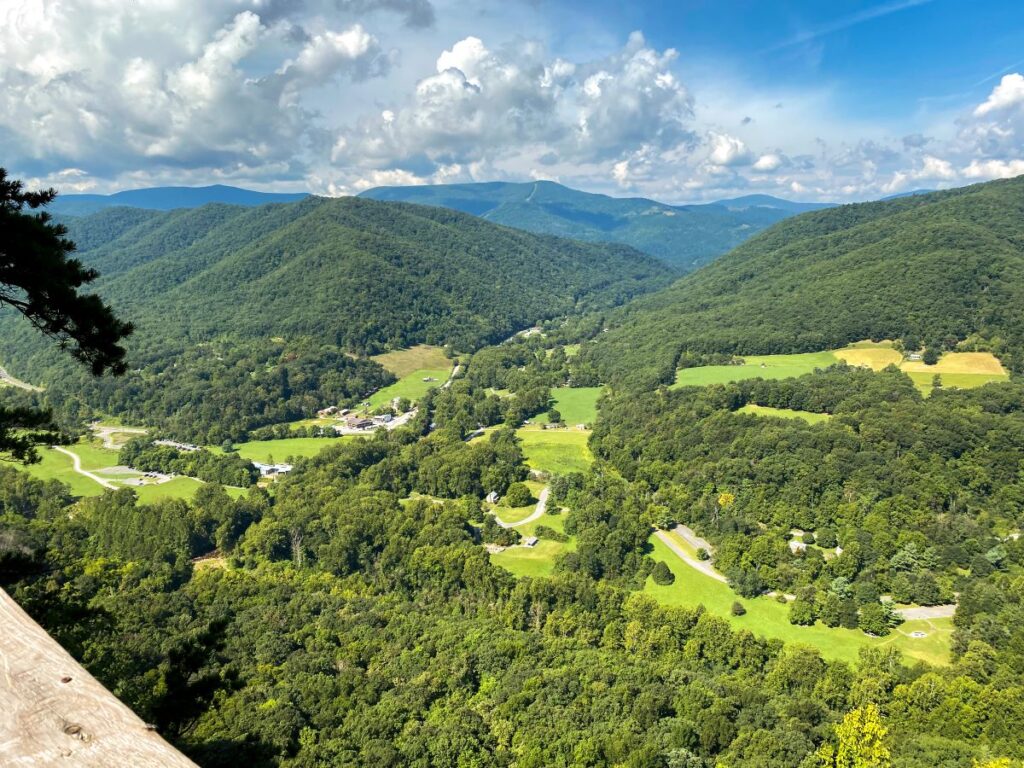
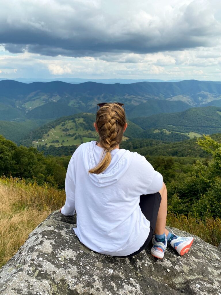
Explore the Views at Spruce Knob
After your hike, grab lunch at Yokum’s and head out toward Spruce Knob, West Virginia’s highest peak at 4863 feet above sea level.
It’s about a 30 minute drive from Seneca Rocks to the Spruce Knob Observation Tower/Whispering Spruce Trail.
The views from the observation tower are pretty meh because the trees block a lot of the view. It’s still cool to be at the highest point in West Virginia though!
The real excitement comes from the panoramic views you’ll get from exploring the rocks and boulders just off the trail. It is 100% worth it!
We sat for a good hour and just enjoyed the view. This is by far the easiest hike with the best views of the whole trip.
Smoke Hole Caverns Tour
If you get back from Spruce Knob and are still looking for something to do in the area, look into a guided tour of the Smoke Hole Caverns, located 15 minutes north of Seneca Rocks. Rates and hours can be found on their website here.
The tour was a little cheesy and definitely geared more towards kids, but there is some interesting history about how the Seneca Indians and early settlers used the caverns to smoke meat and make moonshine.
Relax at your cabin or campsite for the night in Seneca Rocks!
Day 3: Green Bank Observatory and Cass Scenic Railroad
Total driving distance: 62 miles / 1.5 hours
Say goodbye to Seneca Rocks and head out to for Green Bank Observatory and the National Radio Quiet Zone.
Visit the Green Bank Observatory
This 13,000 square mile “quiet zone” is home to the world’s largest steerable radio telescope. Radio telescopes collect energy waves from stars and gases from outer space for research purposes.
There are no radio waves, cell phone towers, or internet signals to ensure no interference with the research going on. If you are using Google or Apple maps, I highly recommend you download them before you enter the NRQZ, as you won’t have cell signal.
You’ll be able to see the telescope from the road and the parking lot from the museum and visitor’s center. The telescope is massive, and could fit over 2 acres of land inside the collecting area!
You can do a guided bus tour and get up close to the telescope, or just explore the museum and watch the informative video. We didn’t have enough time for the full tour, but I would have loved to learn more (we are engineers and by definition, huge science nerds).
Tickets can be bought at the visitor’s center or online ahead of time here.
Ride the Train at Cass Scenic Railroad State Park
After visiting Green Bank Observatory, it’s time to head into Cass and take a ride on the Scenic Railroad.
Cass Scenic Railroad State Park takes you back in time when steam locomotives were commonly used to haul goods across the country. The Cass railroad was built in 1901 and was used to haul logs from the mountains to the mill in Cass.
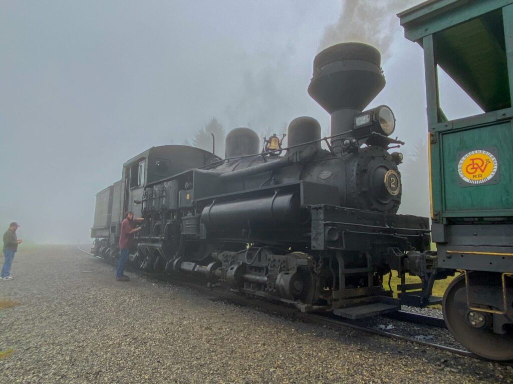
You can take a ride on this railroad yourself!
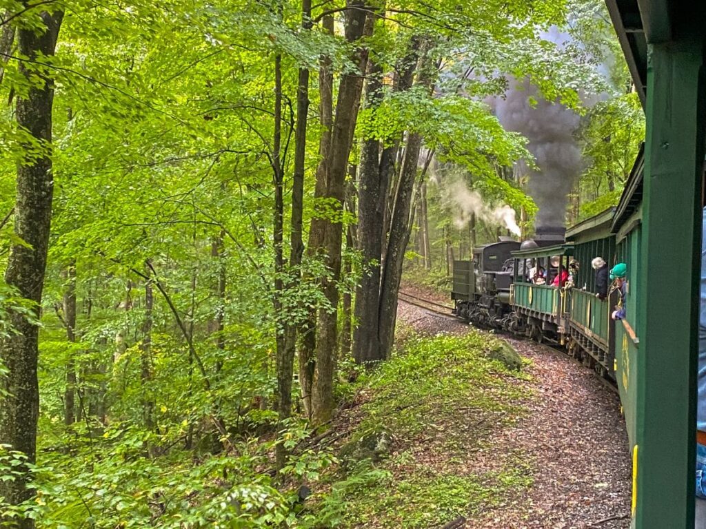
We did the 4.5-hour Bald Knob trip that included lunch. It’s a 22-mile round trip up to West Virginia’s third-highest peak, Bald Knob. You’ll hear about the history of the railroad, learn about steam engines, and stop multiple times to “take on water” so the train can continue making steam.
Make sure you bring a jacket as the temperature can be up to 15 degrees cooler at the top of Bald Knob! We went in early September and were still a little chilly even with a jacket.
The trains do have roofs, but are not enclosed, so dressing for the weather is a must.
I was surprised to see how many people brought their kids on this long of a ride. They were quite restless after an hour or so, so be prepared for that.
The train ride is really the only way to get to Bald Knob. There is a mountain bike trail that leads to Forest Road 267B that you could probably hike, but it isn’t well traveled. Forest Road 267B is also closed to vehicles most of the time, so driving isn’t an option either.
It was unfortunately cloudy, rainy, and misty on the day that we did the Bald Knob railroad trip, so we didn’t get to see the panoramic views from the top.
If I could do it again, I would probably opt for the shorter, 2-hour trip Whittaker trip and grab lunch at The Last Run Restaurant in Cass ahead of time. 4+ hours on a train is a long time, especially if you don’t get to see the views!
Had we gotten to see the views at Bald Knob, it might have been worth it, especially since there isn’t another way to get there.
Book your tickets ahead of time here. You can buy tickets at the visitor’s center the same day if the ride isn’t sold out. I would highly recommend booking ahead of time, especially if you plan to go in peak season during the summer or on a weekend.
Where to Stay Near Cass Scenic Railroad
Snowshoe is a ski town located just 20 minutes from Cass. There are a lot more lodging and dining options here vs. some of the other areas nearby. The selection of restaurants was a pleasant surprise after 2 nights in the middle of nowhere in Seneca Rocks.
I highly recommend staying at Snowshoe Mountain Resort. It’s a popular ski resort in the winter and mountain biking park in the summer.
You’ll save money booking in the off-season (spring and fall) and there are still plenty of restaurants open year-round without the crowds.
You can even take the ski lift up the mountain to check out the views as well!
Day 4: The Greenbrier, Bunker Tour, and Fayetteville
Total driving distance: 135 miles / 3 hours
Seeing the Greenbrier and touring the declassified nuclear bunker underneath it was probably my favorite part of this whole trip. It is definitely worth a stop on your way to Fayetteville and New River Gorge National Park!
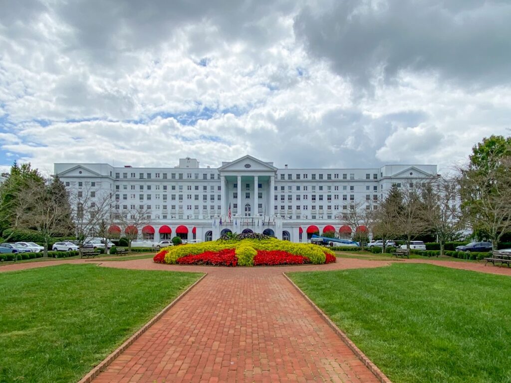
Explore the Greenbrier Resort
The Greenbrier is a luxury resort originally built in 1778 centered around the restorative sulfur waters in the area. Before the Civil War, it became a gathering place for powerful, wealthy families to vacation.
Famous designer Dorothy Draper was hired to redesign the resort in 1946 after it was used as a hospital in World War II. The bright colors and patterns somehow work amazingly together in a maximalism type of way.
Today, it sits on 11,000 acres, has over 700 rooms, 20 restaurants, a spa, golf course, casino, and many more activities. 28 US Presidents have stayed at the resort!
You don’t have to be a guest to walk around the resort and grounds, plus it’s free!

Tour the Greenbrier Nuclear Bunker
By far the most interesting part of the resort is the massive underground nuclear bunker that was constructed in secret during the Cold War. It was a US government top-secret relocation site for members of Congress in the case of nuclear war, until a journalist in 1992 exposed it.
You can book a tour of the nuclear bunker and learn about this absolutely fascinating part of our country’s history. It’s a 90 minute walking tour, so wear comfortable shoes.
If you only do one thing in West Virginia, make this tour be it! I have also written a whole blog post about everything you need to know about touring the Greenbrier Bunker.
Call and book your tour here. The dress code is resort casual and no kids under the age of 10 are allowed. They will make you lock your phone, camera, purse, etc in a locker before the tour.
We ate at Draper’s Cafe for lunch, but there are a ton of casual and fine dining options in the resort. Check out the full list of restaurants in the Greenbrier here.
While I would have loved to stay the night at the Greenbrier, we didn’t want to pay $500+ for one night, so stayed in Fayetteville, Near New River Gorge National Park.
Where to Stay in Fayetteville
Fayetteville is an awesome small town on the New River with some cool restaurants and bars. It’s only 10 minutes from the Canyon Rim Visitor’s Center and the New River Gorge Bridge.
There aren’t any hotels except for a Quality Inn and Comfort Inn, so your best bet is an Airbnb if those aren’t your speed.
If you want a nicer hotel, staying in Beckley is probably your best bet. It will add 30 more minutes of drive time and you’ll be further from the New River Gorge Bridge, but you’ll be closer to the Grandview Overlook and the southern end of the park.
For dinner, I recommend the original Pies and Pints in downtown Fayetteville!
Day 5: New River Gorge National Park & Thurmond
Total drive time: 110 miles / 3 hours
New River Gorge earned the coveted title of US National Park in December 2020 after existing as a National River since 1978.
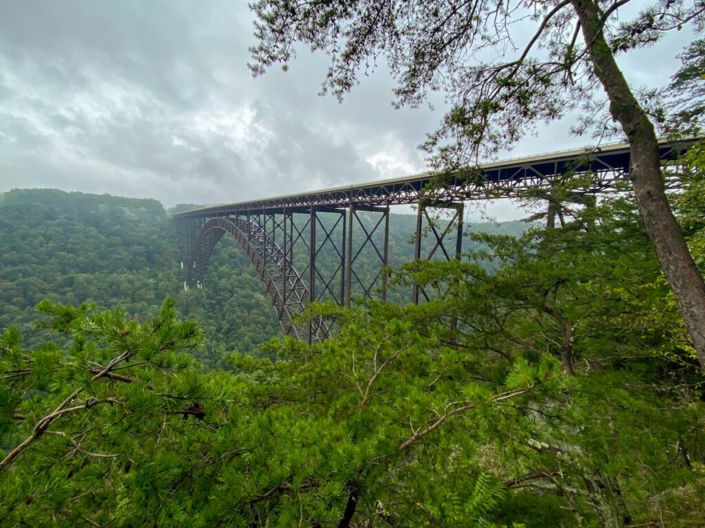
It’s known for its expansive views across the Appalachian Mountains, the New River Gorge Bridge, and outdoor activities such as white water rafting, hiking, mountain biking, and kayaking.
The New River Gorge Bridge opened in 1977 and made travel way easier for locals and tourists traversing the area. It was the longest single-span arch bridge until 2003 (it’s the longest one in the US, but China now has 4 bridges that are longer).
Helpful Things to Know About New River Gorge
There is no fee to enter New River Gorge National Park!
There are also no full-service campgrounds in the park, but you can still camp. The 9 campsites are first come, first serve and it is free. Be prepared though, because there is no drinking water or restrooms!
New River Gorge is a large park, so it’s best to plan your days around close activities to avoid spending most of the day driving between areas. It will take you about an hour to drive between the Canyon Rim Visitor’s Center on the north side of the park to the Sandstone Visitor’s Center on the south side.
Most of the hikes here are pretty short, so you can see and do a lot with just 2 days!
It was unfortunately raining our first day in New River Gorge, so we didn’t end up doing everything on this list.
If the weather is nice or you don’t mind hiking in the rain, this is how I would lay out 2 days in New River Gorge National Park!
Related: New River Gorge Itinerary: How to Spend 1, 2, or 3 Days in New River Gorge National Park
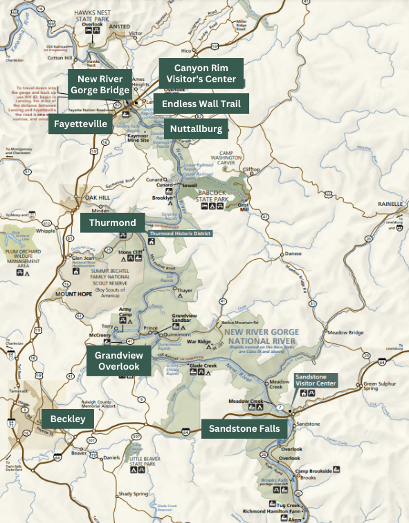
Visit the New River Gorge Bridge Overlook
Grab breakfast in Fayetteville (Cathedral Cafe is a good option) and head to the Canyon Rim Visitor’s Center to view the New River Gorge Bridge Overlook. Today will be all about exploring the highlights of the park.
This overlook is one of the two most Instagrammable photos you likely see when you look up photos of New River Gorge.
The 0.6 mile trail to the overlook is just behind the visitor’s center.
Hike the Endless Wall Trail
Length: 2.8 miles
Elevation gain: 288 ft
Type: Loop or out and back
Difficulty: Easy to moderate
Time: 2 hours
Because of the rain, we didn’t end up hiking this trail which makes me sad (we have a reason to come back though!).
This is a relatively easy hike that will give you great views of the New River and the New River Gorge Bridge. You might get to see some rock climbers climbing the vertical sandstone walls that line the gorge!
This hike can be done as a loop or an out and back. Park at either the Endless Wall trailhead or the Nuttall Parking Lot (Nuttall will be less crowded).
Start from either location and complete the loop, or turn around at Diamond Point. Both ways will be roughly the same distance.
I can’t wait to come back and do this hike!
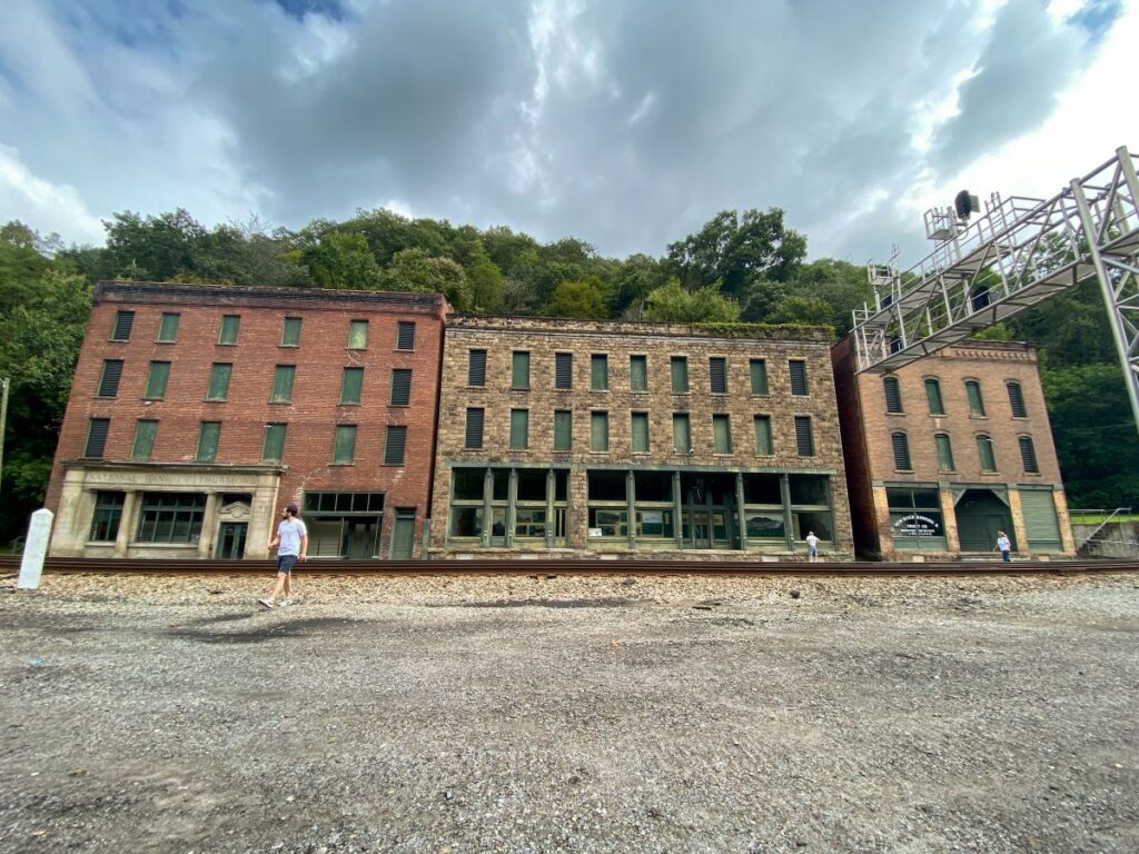
Explore Thurmond
Thurmond is an abandoned coal town located along the New River in the heart of New River Gorge National Park.
It had its heyday back in the early 1900’s and was one of the most prosperous coal transportation sites on the Chesapeake and Ohio Railway. The Great Depression and popularity of diesel powered locomotives led to Thurmond’s decline in the 1930’s and 40’s.
Today, it remains untouched and left as a historical mark of West Virginia’s past. If you’re into history at all, I think Thurmond is worth a visit.
The railroad that runs through the town is still very much active, so stay off the tracks! We saw a train passing through during our quick 30-minute visit.
It’s a 30-minute drive from the Canyon Rim Visitor’s Center, making it the perfect afternoon adventure after lunch.
It’s also the perfect detour on the way to Grandview Overlook, the second most Instagrammable place in New River Gorge National Park.
There isn’t much here, but it was neat to see. It will add about 40 minutes total to your drive time for the day. We thought it was worth it, but if you don’t care that much about history it might not be worth it for you!
Visit the Grandview Overlook
Hop back in the car and route your GPS to the Grandview Visitor’s Center.
As the name describes it, the view at this overlook is Grand! It reminds me a bit of Horseshoe Bend in Arizona, but the West Virginia version of it.
Grab dinner in downtown Fayetteville (we loved the tacos at Southside Junction Taphouse) and spend the evening exploring the town or relaxing at your Airbnb.
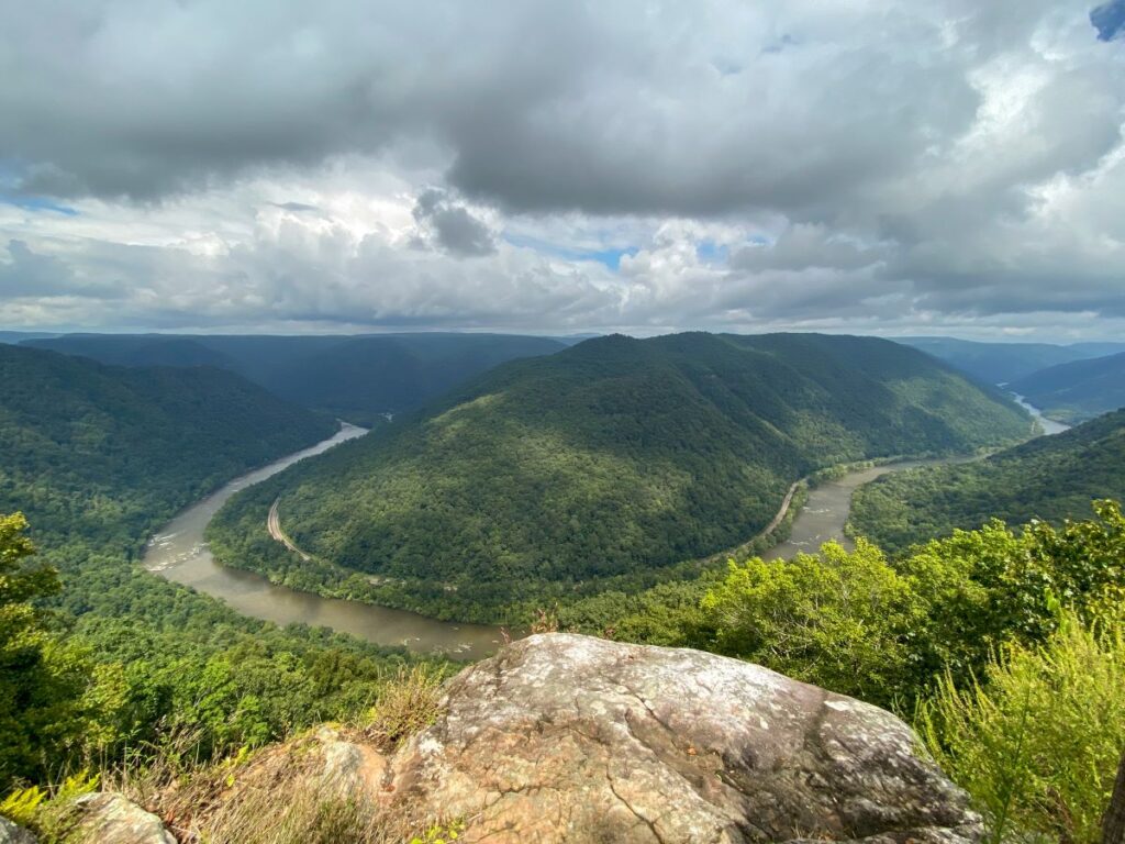
Fun fact: this area of the park used to be Grandview State Park, until it became part of New River Gorge National Park in 2020.
Day 6: Nuttallburg Mine Trails & Charleston
Total Drive Time: 68 miles / 1.5 hours
Did you really go on a trip to West Virginia if you don’t hike to an abandoned coal mine? I was constantly blown away by the terrain and history in this area.
Imagine being a coal miner and having to walk up a mountain every day just to spend it all in a cave mining for coal. And the coal company basically owned your village and paid you in a special currency that could only be spent at a handful of stores in town so you were literally trapped there!
You can get a glimpse of what coal mining life was like by hiking the Nuttallburg Mine Trails.
This is the most strenuous hike of the whole trip, so make sure to eat a good breakfast ahead of time, wear good hiking shoes, and bring plenty of water.
Hike the Nuttallburg Mine Trails
Length: 5 miles
Elevation gain: 1007 ft
Type: Out and back
Difficulty: Strenuous
Time: 3 hours
You can explore parts of this area separately, or see them all in one hike by taking each connecting trail from the Nuttall Coal Mine all the way down to the Nuttallburg village by the river.
I would recommend grabbing supplies to have lunch during the hike if you plan to do the whole route. We just grabbed some sandwiches and chips from the Subway in Fayetteville and put them in our backpacks.
This trail was totally empty when we did it on a weekday in September. It’s one of the least-popular trails, I assume due to the difficulty and availability of easier trails. But being able to explore this much of West Virginia’s history without any crowds was really really cool.
The NPS has each section marked as a different trail, but they all connect and you can do it as one out and back hike (stats above are shown for the entire hike). I would classify this hike as strenuous (particularly the Conveyor Trail, marked (2) on the map).
You can do this hike from either starting point (Headhouse Trail at the top of the gorge, or from Nuttallburg). The trail access at the Headhouse trailhead is much easier to get to, so I would recommend starting there and hiking down the gorge first.
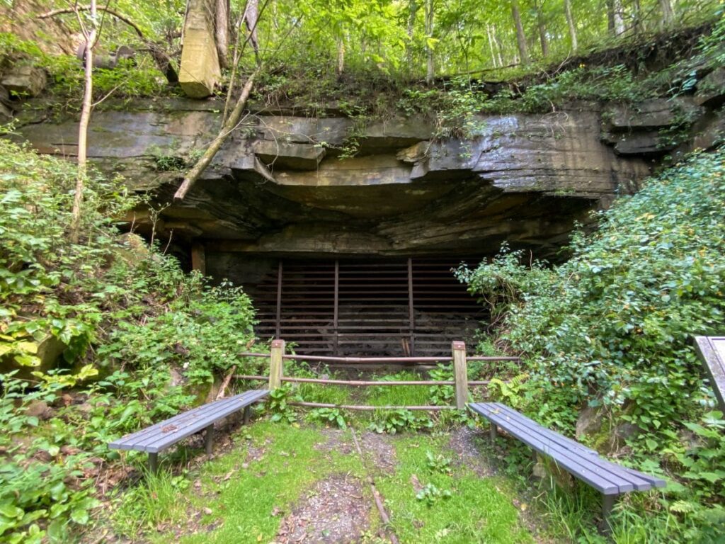
Start at the Headhouse Trail
The headhouse trail (marked (1) on the map), can be done as a short out and back or the first part of the entire hike. If you only do this part of the trail, you’ll hike 1.3 miles total with 393 feet of elevation gain and skip the most strenuous part of the trail.
Park at the Headhouse Trail trailhead by the Nuttallburg Cemetery and Short Creek. You’ll hike down through the woods to an abandoned coal mine and see the beginning of the conveyor system that took the coal from the mine down to the railroad at the river.
You can get up close to the mine and feel the cool air coming out of it (it’s blocked off so you can’t go in, for obvious reasons). This area is also home to several species of endangered bats.
Hike Down the Conveyor Trail
If you choose to continue the hike down to Nuttallburg, you’ll follow the conveyor system further down into the gorge.
You’ll descend some pretty steep switchbacks through the woods, so be prepared with good shoes and take your time! This part of the hike is short (only 0.8 miles) so it will be over quick.
The trail is also a bit overgrown and we saw quite a few spider webs, so grab a stick to clear anything out of your way.
Once you get past this part of the trail, the rest is easy and flat.
Explore the Village of Nuttallburg
Follow the signs for trails 4, 5, 6, and 7 to explore the village of Nuttallburg and the old railroad.
You can see the new railroad (yes, it is active!) just through the trees that replaced the old one.
If you skipped the strenuous Conveyor Trail, you still explore the village by taking Keeny’s Creek Road all the way down to Nuttallburg.
The road is very narrow and steep, so be careful. 2 cars can’t fit on the road in some spots, so you might need to back up if someone is coming the other way. But based on the lack of people we saw, I doubt you will come across anyone else on the way.
I don’t know if I would recommend driving to the Nuttallburg lot unless you have a smaller 4×4 vehicle. It will also add another hour to your total drive time for the day.
If you are brave enough to drive there, park in the Nuttallburg lot and explore the village!
We had lunch at one of the benches near the railroad before exploring. You’ll see old foundations of homes, stores, and churches from the original Nuttallburg village along with the conveyor that loaded coal from the mine into the rail cars. It’s amazing that so much of this history is left to explore!
The not-so-fun part is coming back up. Take your time, bring lots of water, and stop for a break at the coal mine to cool off!

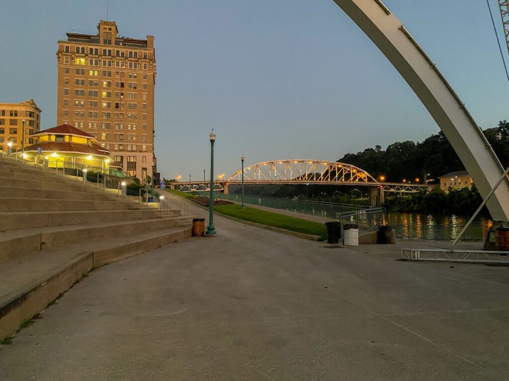
Where to Stay in Charleston
Once you’ve finished your hike for the day, it’s time to head out for Charleston for a night out on the town to conclude your West Virginia road trip.
Charleston is West Virginia’s largest city, so there are plenty of hotels to choose from.
The Courtyard by Marriott Charleston Downtown, Holiday Inn Express Civic Center, and Embassy Suites Charleston are all decently affordable options within walking distance to downtown.
We checked into our hotel, showered, and walked to grab dinner and check out a few of the breweries downtown. The riverfront park made for a nice walk back to our hotel.
The Black Sheep had great burritos for dinner and a good beer selection. Fife Street and Short Story Brewing are just a block away if you want to check out more of West Virginia’s beer scene.
A local craft beer after a long hike is one of my favorite experiences when traveling!
Day 7: Drive Home
Today concludes your road trip through West Virginia! Grab brunch in downtown Charleston or at your hotel and head home.
If You Have More Time
If you’re a 9-5-er like me, you might value having a day at home to reset before returning to work instead of spending one more day on your trip.
Back in my early 20’s, I used to spend as much time as possible on a trip, and would often get home Sunday night at midnight and wake up for work the next day like normal!
Now that I’m in my late 20’s, that extra day at home to catch up is worth it.
This itinerary is designed for you to leave Friday after work and get home Saturday. However, if you’d rather drive home on Sunday instead and spend Saturday exploring, I would spend the extra day in New River Gorge National Park.
I would have loved to do more hikes here (particularly in the Grandview and Sandstone areas of the park) and/or do the guided Bridge Walk Tour!
If hiking isn’t your thing (not sure why you’ve read this far if it isn’t!) you could easily spend another day in Charleston.
I hope this 7-day West Virginia road trip itinerary helps you plan your trip to the wild and wonderful state!
If you have visited West Virginia, let me know if you’ve done anything from this West Virginia road trip itinerary in the comments below!
-Megan
Pingback: New River Gorge Itinerary | How to Spend 1, 2, or 3 Days in New River Gorge National Park - Engineer to Explore
Very useful, and to the point!