
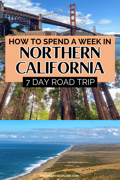
California as a whole is known for a plethora of awesome road trips just begging to be taken. The northern part is known for its rugged coastline, the famous Golden Gate Bridge, towering Redwood trees, and even more stunning scenery.
So when my husband and I found a great deal on flights to San Francisco, we couldn’t resist booking them and figuring the rest out later.
I went into planner mode and quickly got overwhelmed with all the cool places to see in northern California! (And then figuring out how to fit it all into our week-long PTO during the week of Labor Day!)
After about a week of research, I narrowed down this ultimate northern California road trip itinerary that is geared toward hiking and outdoor adventures.
You’ll start and end in San Francisco and explore Point Reyes National Seashore, the northern California coast, Redwood National Park, and Lassen Volcanic National Park.
If you’re looking for an epic Northern California road trip geared toward hiking that you can easily fit into 4 or 5 PTO days, keep reading!
How to Get to Northern California
If you’re not local or within driving distance, flying into San Francisco is probably your best option for this itinerary. Sacramento is also a good starting point as well!
You will have to rent a car to get around.
4×4 isn’t necessary, but this itinerary requires a lot of driving so I recommend renting a car that you’re comfortable in (maybe skip the Mitsubishi Mirage this time- I know it’s cheap but you’ll regret it later!).
We spent the week driving around in a Buick Encore, which was fine for just the two of us, albeit a bit cramped at times!
Related Posts About Destinations in This Itinerary:
- The Ultimate Point Reyes Day Trip Itinerary
- 1-Day Redwood National Park Itinerary & Guide
- 14+ Best Things to Do in Redwood National & State Parks
- The Ultimate 1-3 Day Lassen Volcanic National Park Itinerary
- 13 Fantastic Things to Do in Lassen Volcanic National Park
- 7 Best Hikes in Lassen Volcanic National Park
When is the Best Time to Visit Northern California?
Most of northern California is pleasant to visit year-round. However, you’ll want to do this northern California road trip in the summer or early fall since you’ll be visiting Lassen Volcanic National Park.
This National Park sits at an elevation between 5600 and 10,500 feet so snowfall closes the roads for most of the year!
The coast, Point Reyes National Seashore, and Redwood National Park can all be pleasantly visited year round. We did this trip the week of Labor Day which was perfect!

Helpful Tips for This Northern California Road Trip
This northern California road trip just scratches the surface of the beauty and wonder in the area.
At the end of this post, I have suggestions for other places to add on within a half-day drive if you have more time. But if you’re a 9-5-er like me and only have 4-5 days of PTO to use for your trip, this northern California road trip itinerary will work perfectly for you!
This itinerary focuses on 3 main points of interest: Point Reyes National Seashore, Redwood National and State Parks, and Lassen Volcanic National Park.
You will need a free permit to access Tall Trees Grove and Fern Canyon at Redwood National Park between May 15th and September 15th. I have more details on this in the day 3 section below, but here is the link to book permits if you want to get a head start!
Much of Lassen Volcanic National Park sits at an elevation of more than 7000 feet, so hiking will feel more strenuous than you’re likely used to. Use caution and assess your fitness level before choosing your hikes!
Many of the roads on this road trip (especially The 1 up the coast) are very winding and twisty. If you’re prone to car sickness like me, I highly recommend bringing some emergency pretzels, ginger ale, and Dramamine with you in the car!
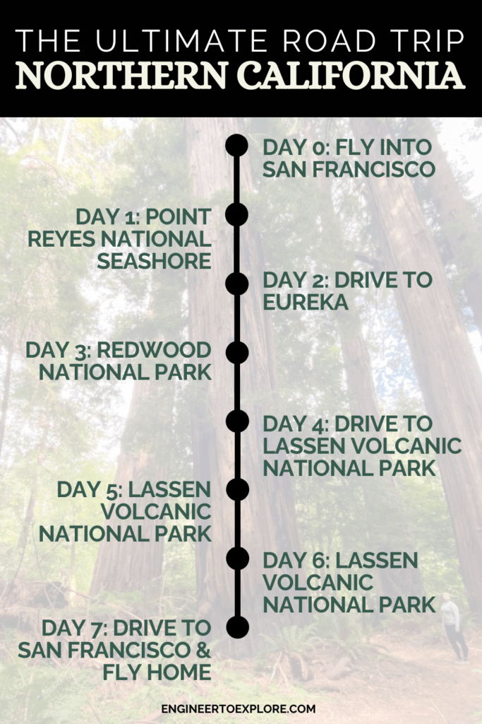
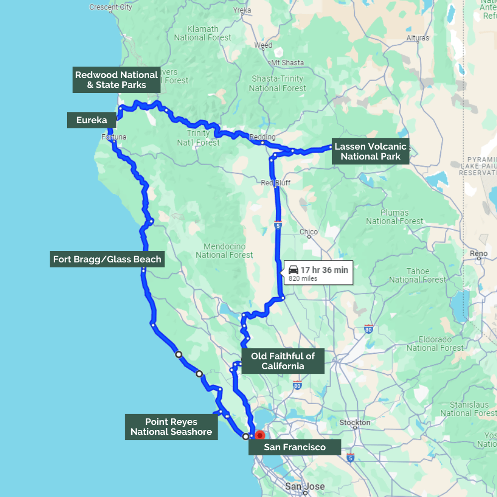
The Ultimate Northern California Road Trip Itinerary
Here is the route you’ll be taking this week!
Day 0: Fly into San Francisco
I call the first day of any trip “Day 0” because we usually leave late after work on a Friday and are just focused on getting to our destination.
Use your day 0 to get to San Francisco, pick up your rental car, and spend the night near the airport.
You won’t be spending any time in San Francisco on this northern California road trip, so choose a safe, convenient place to start the next day!
Where to stay: The Grand Hyatt at SFO (attached to the airport and accessible by the AirTrain, it’s quite expensive though!) or The DoubleTree by Hilton San Francisco Airport North (more budget-friendly option)
Day 1: San Francisco to Point Reyes National Seashore
Total Driving Distance: 60 miles / 1.5 hours
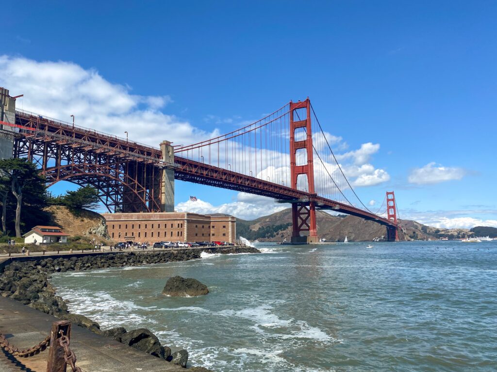
Fort Point
Start your northern California road trip by heading out for Point Reyes National Seashore! Point Reyes Station is a little over an hour north of San Francisco if you take The 1 up the coast.
I recommend a quick stop at Fort Point just before you cross the Golden Gate Bridge.
Fort Point was built in the 1800’s to protect the San Francisco Bay. It remains as a National Historic Landmark and provides a spectacular view of the Golden Gate Bridge from underneath!
We were amazed at how they preserved the historic fort when building the Golden Gate Bridge around it!
When you’re done at Fort Point, keep heading north and cross the Golden Gate Bridge. (And don’t worry about paying a toll on the Golden Gate Bridge, there is only a toll if you’re coming south into the city!)
Once you cross the Golden Gate Bridge, you have two route options for getting to Point Reyes: The 1 up the coast, or the 101 inland.
The 1 is the slightly longer, but more scenic route along the coast (I highly recommend this route). The roads are quite twisty, so be prepared if you’re prone to carsickness.
You’ll drive through Stinson Beach, a cute beach town that can make a nice pit stop if you can find parking!
Point Reyes National Seashore
Point Reyes National Seashore is a truly unique place to visit. This part of the coast doesn’t even feel like California at all!
The amazing beaches, coastal bluffs, and abundant wildlife provide a ton of fantastic photo opportunities to enjoy the protected shoreline.
I recommend packing layers here and being prepared with a rain jacket. The weather can change quite rapidly, and go from warm and sunny to foggy and rainy really quickly!
Related: The Ultimate Point Reyes Day Trip Itinerary
Grab lunch in Point Reyes Station or Inverness before exploring, as there aren’t any restaurants once you pass Inverness. Sir Francis Drake Boulevard is the main drag through Point Reyes, and there are a lot of interesting and scenic stops along the way.
Here are the can’t-miss stops in order as you make your way down Sir Francis Drake Boulevard:
- Point Reyes Shipwreck: Located behind the Inverness Store, there is a short walking path down to this famous photography spot
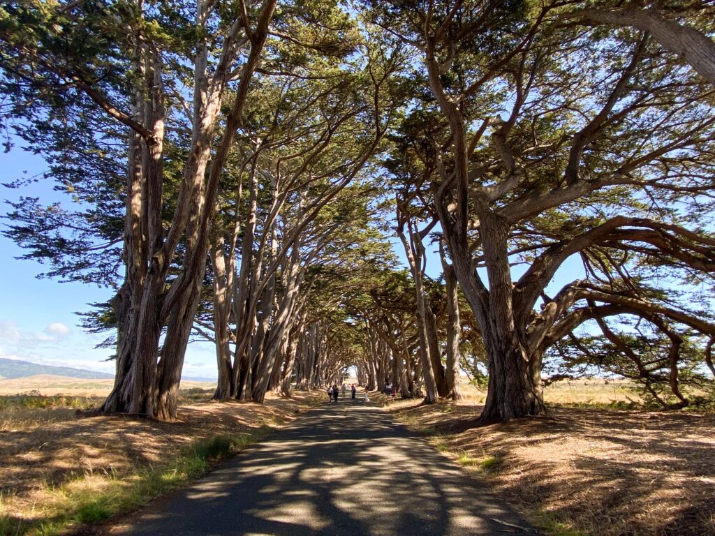
- Cypress Tree Tunnel: Gorgeous walking path lined with cypress trees that leads to the historic KPH Maritime Radio Receiving Station
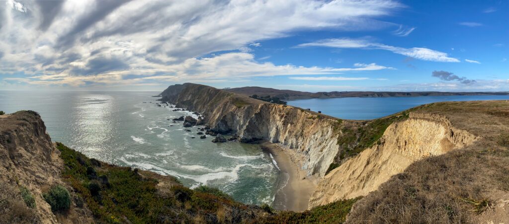
- Chimney Rock Trail: Easy, 1.9-mile hike through the Point Reyes Headlands with spectacular scenery
- South Beach Overlook: Great spot for taking photos of the coast
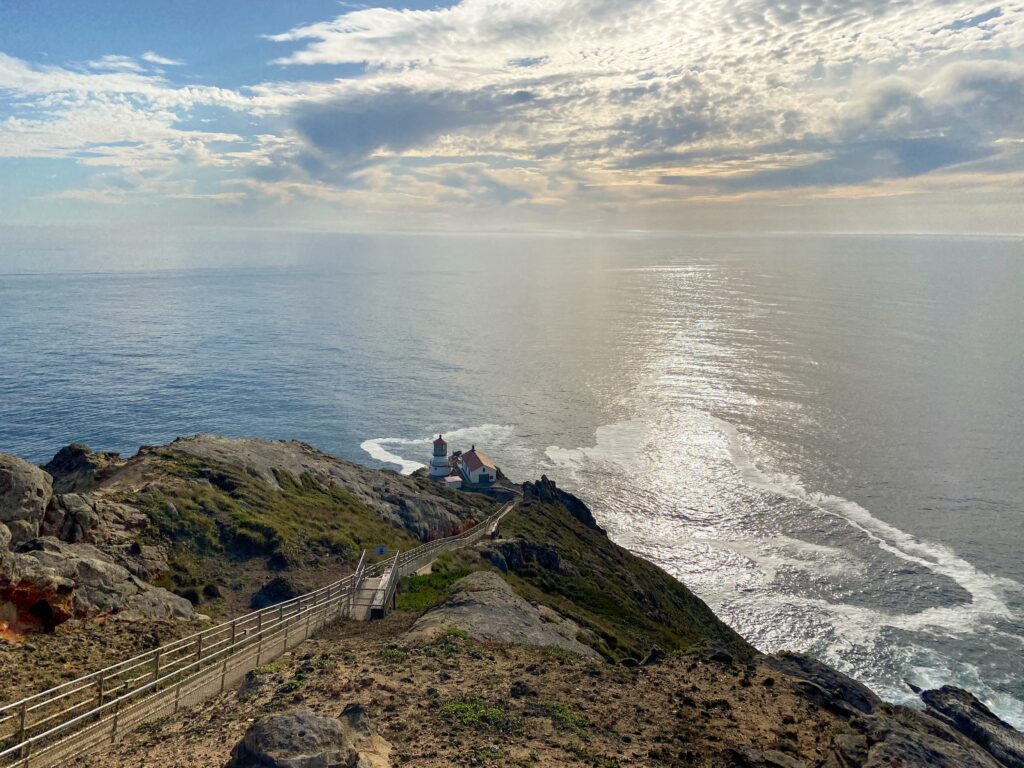
- Point Reyes Lighthouse: The most famous spot in Point Reyes National Seashore located at the western tip of the Point Reyes Headlands peninsula
If you want more details on how to make the most of a day trip to Point Reyes, check out this post: The Ultimate Point Reyes Day Trip Itinerary.
Our Experience: When we visited Point Reyes in the late afternoon the Saturday before Labor Day, the lighthouse parking lot was absolutely packed! So we backtracked a bit and did the Chimney Rock Trail first, and then came back to the lighthouse an hour later and there was plenty of parking.
Where to Stay Near Point Reyes
We didn’t end up staying near Point Reyes, but here are some highly-rated hotels that would make great options:
- Olema Cottages: peaceful, adorable cottages with a great location near Point Reyes
- Point Reyes Station Inn: romantic bed and breakfast within walking distance of the shops and restaurants in Point Reyes Station
- The Inn at Roundstone Farm: serene bed and breakfast with a full country breakfast every morning
This was probably my biggest regret of our whole trip. We didn’t stay near Point Reyes, and ended up driving 2 hours north to stay just south of Mendocino.
I totally underestimated how long it would take to drive from the lighthouse back to the mainland. We also got a later start than we originally planned (we stayed with family friends south of San Francisco the night before and hung out with them that morning).
Because of that, we ended up driving the twisty, scenic roads at night, which was quite scary and disappointing that we missed the views!
Learn from my mistakes and be realistic with how much you can pack into a day!
Day 2: Point Reyes to Eureka
Total Driving Distance: 277 miles / 6 hours
Day 2 of your northern California road trip is all about driving up the coast! This is a big driving day, but the only thing on the itinerary is making it to Eureka, so take your time and enjoy the stops!
Mendocino
Your first stop of the day is Mendocino. It will take you about 3.5 hours to drive here from Point Reyes Station so this makes a good lunch spot.
Mendocino is known for its quaint small town atmosphere with lots of cafes, B&Bs, and locally-owned shops. There are lots of walking trails along the coast to explore as well.
Personally, I thought Mendocino was a bit overrated given all the hype. Maybe that’s because we were there around 10 am and most places weren’t open yet, or because shopping really isn’t our thing on vacation, but hey, we can check it off the list!
Fort Bragg and Glass Beach
Just up the road is the small town of Fort Bragg, not to be confused with the military base in North Carolina.
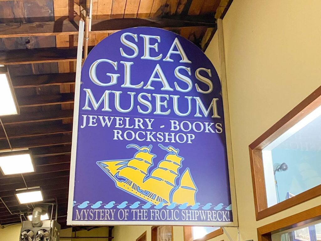
There are some quirky attractions here, like Glass Beach, the Seaglass Museum, and the Skunk Train. Explore for as little or long as you like!
The Seaglass Museum is Captain Cass Forrington’s personal collection of sea glass. It’s the largest collection in the world. The museum is free to visit, but donations are welcome. Captain Cass might be the most interesting man in the world- you’ll get what I mean when you visit!
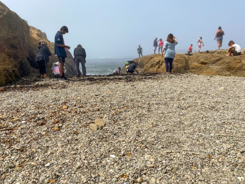
Glass Beach is another popular attraction in Fort Bragg.
This small stretch of beach is covered in small pieces of smooth glass that wash up on the shore permanently. Believe it or not, but this area used to be a dump for nearby residents!
The glass remains along with sea glass that is tumbled in the ocean and washed up on Glass Beach for all tourists to pick through. Some official-looking websites say that it is illegal to remove glass from the beach, but Captain Cass insisted that it was perfectly fine to take a few pieces.
When you think about it, all the glass is literal trash so I don’t know why taking a few pieces home would be a problem!
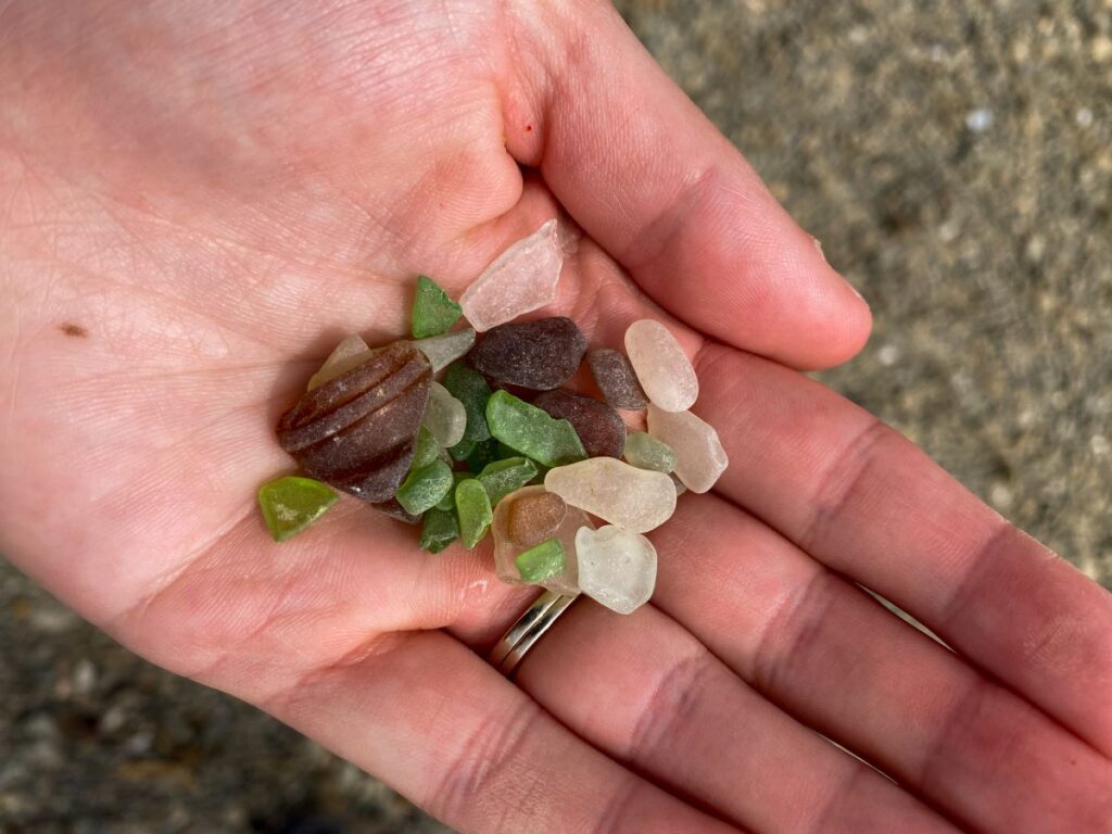
Also note that 99% of the photos you see online of Glass Beach are very heavily photoshopped! The actual beach looks like this:
Drive-Thru Tree (Optional)
As you make your way north, you’ll see a sign for the “Drive-Thru Tree Park.” It is just what it sounds like, there is a giant redwood tree that you can drive your car through!
We couldn’t resist at least checking it out, so we got off the highway and headed that way. We were surprised that it cost $15 to drive through!
Despite the steep price, we decided to do it anyway.
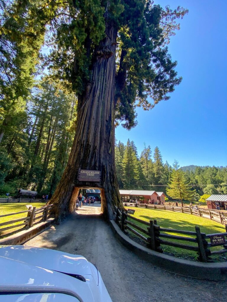
And FYI, if you have a large car such as a Tahoe or Expedition, you will not fit through the tree (the Tahoe in front of us had to back out because he was too wide to fit through!).
There is a gift shop and restroom here as well.
Should you do this? I would argue that it wasn’t worth the price. But will you do it anyway? Probably.
Eureka
Continue north until you reach your accommodations in Eureka. This will be your home base for the next 2 nights as you explore Redwood National & State Parks.
Eureka is kind of a weird town. It was oddly empty when we went and there was kind of a weird vibe. I can’t really put my finger on it, so you’ll have to go see for yourself!
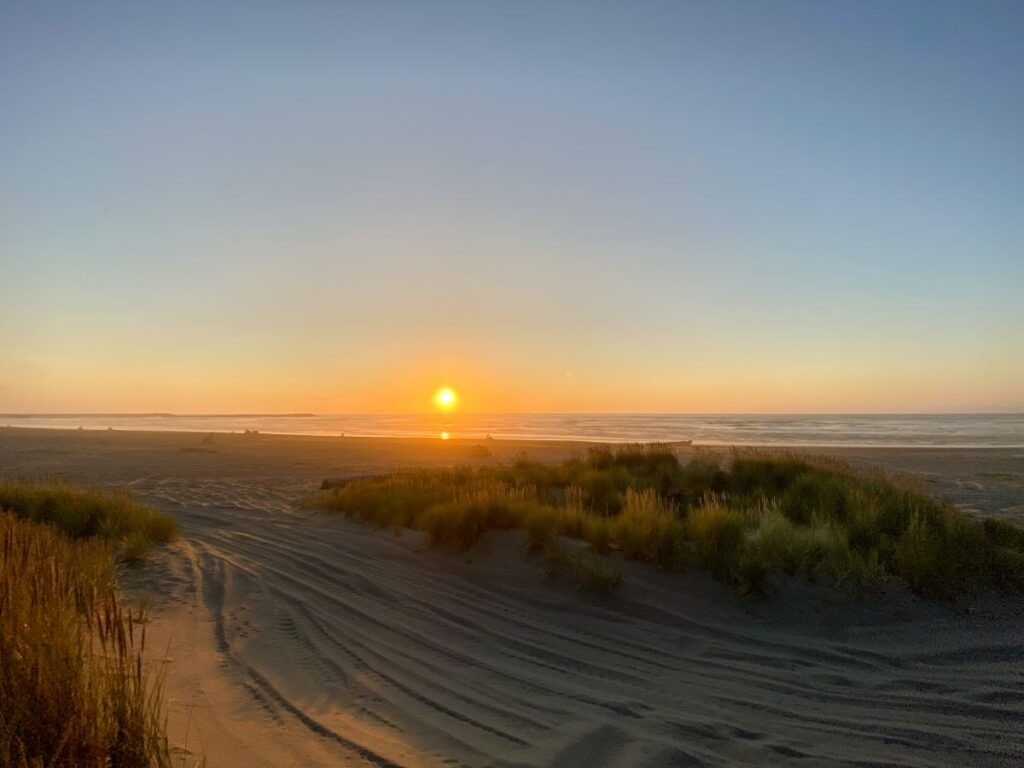
There aren’t a ton of restaurants in town, but we really enjoyed Lost Coast Brewing. Head over to Samoa Beach for an amazing sunset to end your day of travel.
Where to Stay Near Eureka
The Holiday Inn and the Front Porch Inn get good reviews. We stayed at the Best Western Bayshore Inn, but I don’t know if I would recommend it!
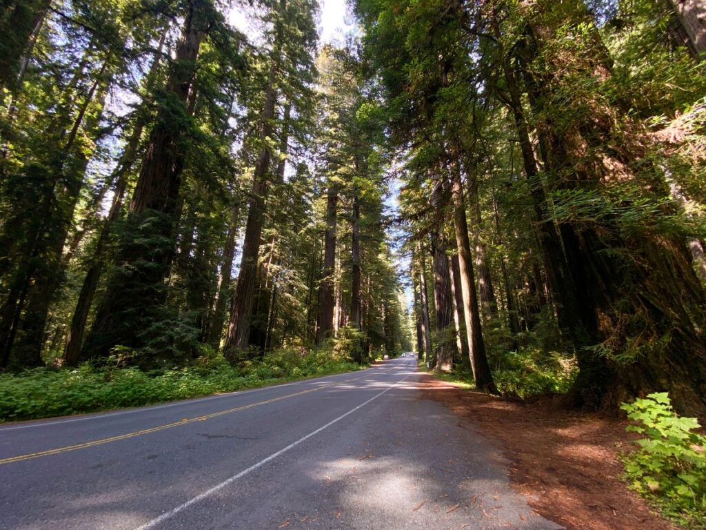
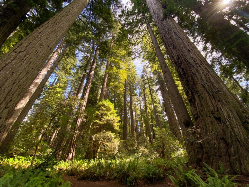
Day 3: Redwood National and State Parks
Total Driving Distance: 170 miles / 3 hours (round trip)
Spend day 3 of your northern California road trip exploring Redwood National & State Parks! This area is home to the tallest trees in the world, with some being over 300 feet tall!
This set of 4 parks includes Redwood National Park, Prairie Creek Redwoods State Park, Jedediah Smith State Park, and Del Norte Coast Redwood State Park.
The NPS and California State Parks work together to manage this region that protects 40 miles of coastline, endangered wildlife, and 45% of the old-growth redwood rainforests. Old-growth forests refer to the trees that existed before early settlers started heavily logging the region in the mid-1800’s.
Related: 1-Day Redwood National Park Itinerary & Guide
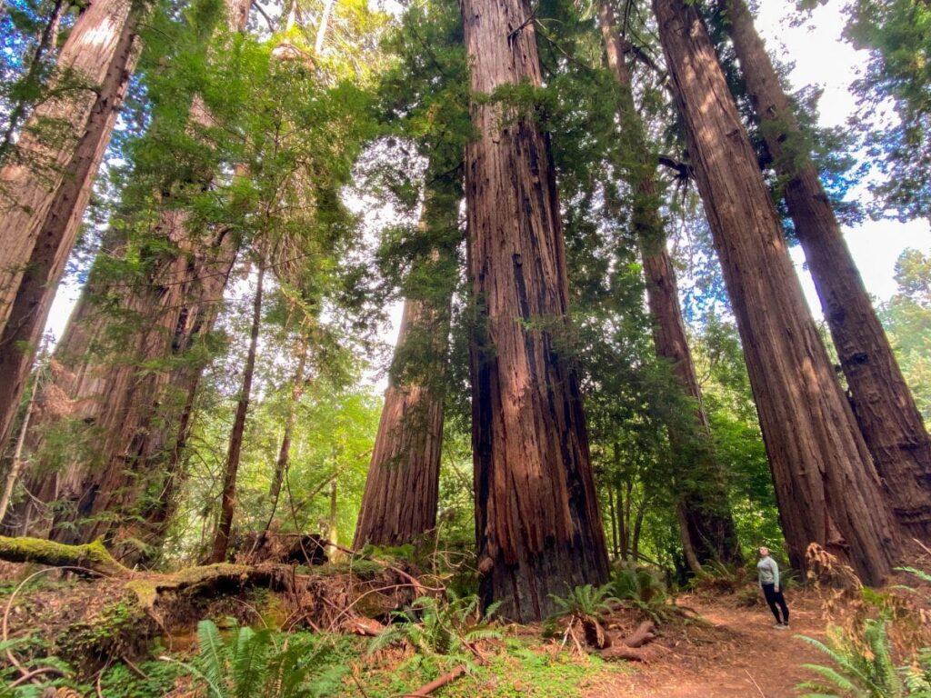
Oh, and did I mention that over 95% of these old-growth redwood trees have been cut down since then? So not only are the remaining 5% of these old growth forests the tallest trees in the world, they’re also some of the rarest.
And to top it all off, parts of Jurassic Park 1 and 2 were also filmed here!
Eureka is the closest major town to the south and Crescent City is situated north of the parks.
I wrote a whole blog post on how to spend a day in Redwood National & State Parks, so check that out for more details on the following items below.
You will need a free permit for the Tall Trees Trail and Fern Canyon, but I have suggested alternative options in case you don’t get one! We got one for Tall Trees but not Fern Canyon sadly.
Here is my suggested itinerary:
- Morning: Hike the Tall Trees Trail (permit required) or the Trillium Falls Trail (no permit required)
- Midday: Picnic lunch at Redwood Creek Overlook and visit the Lady Bird Johnson Grove
- Afternoon: Visit Fern Canyon (permit required + $12 CASH ONLY entrance fee unless you have the America the Beautiful National Park Pass or a California State Parks Pass) and/or the Stout and Simpson-Reed Grove (no permit required) and drive the Newton B. Drury Scenic Parkway
- Evening: Grab dinner in Crescent City or Eureka and watch the sunset (the Crescent Beach Overlook, Samoa Beach near Eureka, or the Redwood Creek Overlook make great locations!)
Related: 14+ Great Things to Do in Redwood National & State Parks
We enjoyed sitting on the patio at SeaQuake Brewing in Crescent City for dinner.
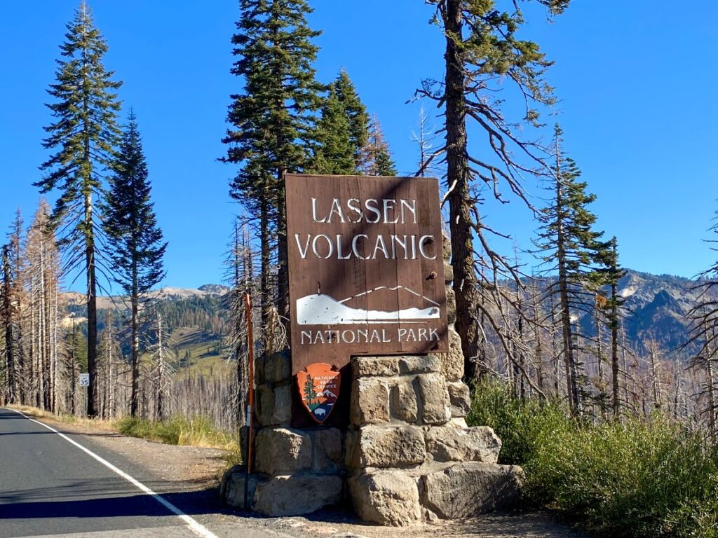
Day 4: Eureka to Lassen Volcanic National Park
Total Driving Distance: 254 miles / 5.5 hours
Say goodbye to the Redwoods and head out toward Lassen Volcanic National Park on day 4 of your northern California road trip! This is another long driving day, but it will be worth it, I promise!
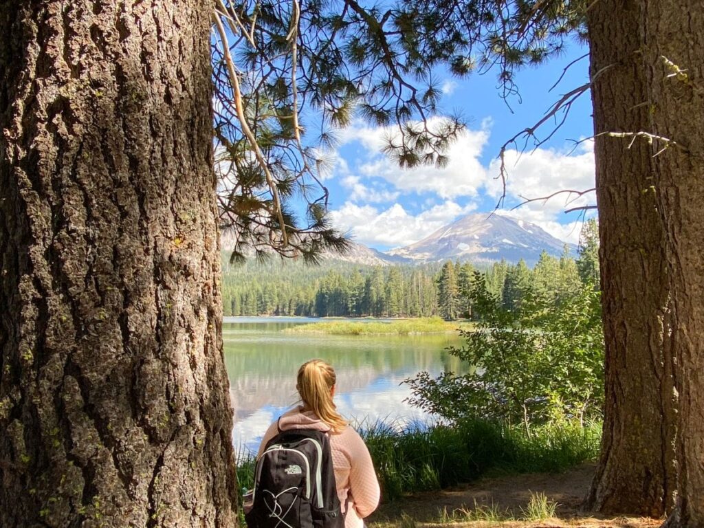
Lassen Volcanic National Park is the most underrated hidden gem of northern California. You’ll see bubbling hydrothermal areas, all 4 types of volcanoes, alpine lakes, waterfalls, and beautiful scenery.
The park’s namesake, Lassen Peak, last erupted in 1915 where it devastated nearby areas and deposited volcanic ash 200 feet away.
Related: The Ultimate 1-3 Day Lassen Volcanic National Park Itinerary
And the best part? People don’t even know it’s here so there are hardly any crowds!
Head west on CA-299 and stop for lunch in Redding.
2021 Dixie Fire Update
During the summer of 2021, the Dixie Fire burned almost 1 million acres in Northern California, making it the largest single fire in California history. The southeast corner of Lassen Volcanic National Park was the most severely burned area in the park.
Lassen Volcanic National Park is open, but remnants of the fire damage are still evident in some areas. The Drakesbad Guest Ranch (the only in-park lodge) remains closed for the 2023 season.
The Warner Valley and Juniper Lake areas of the park are closed (no access via Warner Valley and Juniper Lake roads).
This means that the trailheads to some popular hikes, like Devil’s Kitchen and Boiling Springs Lake, are also closed. You can get to the trail, but it takes a significant walking detour to get to these areas (I’m talking an extra 7-10 miles in addition to the posted trail lengths).
There are still plenty of fantastic ways to spend a few days at Lassen despite some areas being closed!
As always, check the NPS website for the latest info on reopening plans after the Dixie Fire before planning your trip.
Lassen Volcanic Scenic Highway
You will enter Lassen from the north side near Manzanita Lake.
I highly recommend taking the time to stretch your legs by hiking the Manzanita Lake loop. This is a 1.9-mile, flat hike around the lake with fantastic views of the Lassen Peak!
After your hike, make your way down the Lassen Volcanic Scenic Highway to your accommodations. There are a lot of short, interesting stops along the way.
I recommend checking out the following:
- Hot Rock: A 3-ton rock that was moved here via lava during the 1915 Lassen Peak eruptions.
- Devastated Area Interpretive Trail: Short, gravel trail with signs explaining the destruction of the 1915 Lassen Peak eruptions.
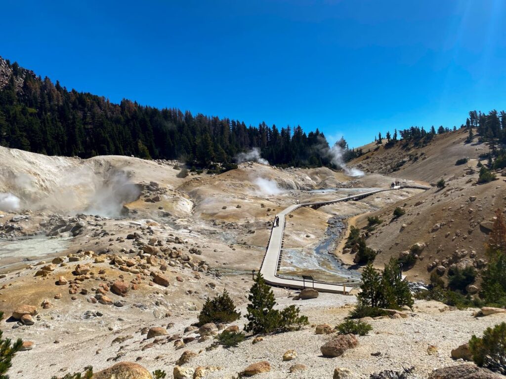
- Bumpass Hell Trail (you can also save this hike for tomorrow): This 2.7-mile, moderate trail leads you around the Bumpass Mountain and down into a densely-concentrated hydrothermal area full of bubbling mud pots and pungent fumaroles. This is the most popular hike to do at Lassen Volcanic National Park!
- Sulfur Works: Short, boardwalk trail right off the road with pungent, sulfur-smelling hydrothermal areas
Check into your hotel and grab dinner in Chester.
Related: 13 Fantastic Things to Do in Lassen Volcanic National Park
Where to Stay Near Lassen Volcanic National Park
There are a few small towns located on the southern side of Lassen that provide a convenient location for exploring for a few days.
Chester, Mineral, and Mill Creek are all less than 30 minutes from the south entrance gate to the park. The south entrance is also closer to a lot of the main attractions in Lassen.
However, the restaurant selection here is pretty slim and a lot of places are closed Monday – Wednesday. Timber House Brewing is the best restaurant in town but they’re only open Thursday – Monday.
There is a nice grocery store in Chester with grab-and-go items as a backup though!
You’ll be spending the next 3 nights here. I would recommend looking for an Airbnb close to these towns, or booking one of the following accommodations:
- St. Bernard Lodge: Affordable bed and breakfast in Mill Creek. We stayed here for 3 nights and would recommend it! The breakfast is made to order and included in the nightly price, but you won’t have a private bathroom, so keep that in mind!
- Timber House Brewery and Lodge: Accommodations in Chester that are attached to a great brewery!
- Best Western Rose Quartz Inn: Clean, basic hotel in Chester with free breakfast.
Day 5: Lassen Volcanic National Park
Total Driving Distance: 70 miles / 2 hours (round trip)
Your first full day in Lassen Volcanic National Park will be all about hiking 1 or more of the most popular trails in the park!
If you’re up for the challenge of hiking to the top of the Lassen Peak, this is the day to do it. The Lassen Peak Trail is a very strenuous, 5-mile climb up to the top of the Lassen Peak with almost 2000 feet of elevation gain. This is the highest point in the park at 10,500 feet!
If you plan to do this hike, please be prepared and assess your fitness level. There will be snow near the top and the weather can change instantly at elevation. The trailhead could be warm and sunny, but it’s important to be prepared for rain, snow, hail, and/or lightning at the peak!
We originally planned to do this hike, but decided against it after reading some of the AllTrails reviews, mainly due to the reports of changing weather that we were definitely not prepared for.
If the Lassen Peak Trail is a bit too strenuous for you, I would hike the Bumpass Hell Trail in the morning (if you didn’t already hike it yesterday) and pick one more trail from this list for the afternoon:
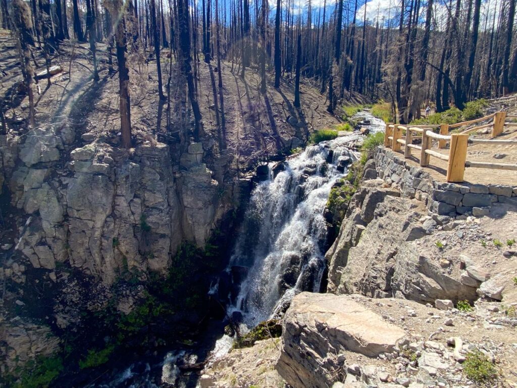
- Kings Creek Falls Trail: Moderate, 2.8-mile hike with almost 700 feet of elevation gain (AllTrails has the elevation wrong) down to an impressive waterfall. The scenery on this hike is unreal- you’ll get panoramic views of the park, up close and personal with burned trees from the 2021 Dixie Fire, and walk through lush meadows. The rock scramble on the way back up is fun too!
- Chaos Crags to Crags Lake Trail: Moderately challenging, 4-mile, out-and-back hike with 984 feet of elevation gain. You’ll hike to Crags Lake and enjoy the scenery of these plug volcanoes, the Chaos Crags, on the way.
- Mill Creek Falls Trail: Moderate, 3.4-mile trail with 767 feet of elevation gain to the tallest waterfall in Lassen Volcanic National Park. You’ll be rewarded with views of Brokeoff Mountain and Mt. Diller.
If hiking isn’t your thing, you can also go kayaking on Manzanita Lake or go swimming in Bathtub Lake (yes, it is called “Bathtub” Lake because it is the smallest, warmest lake in the park!).
Related: 7 Best Hikes in Lassen Volcanic National Park
Day 6: Lassen Volcanic National Park
Total Driving Distance: 188 miles / 3.5 hours
On your last day in Lassen Volcanic National Park, you’ll visit a fantastic nearby state park and hike my personal favorite trail, the Cinder Cone!
Burney Falls State Park
Grab breakfast and hit the road for Burney Falls State Park.
I know this part of the itinerary isn’t technically in Lassen Volcanic National Park, but Burney Falls is a fantastic state park with one of the most beautiful waterfalls I’ve ever seen!
And it’s only an hour and a half from Chester.
The hike down to Burney Falls is short and sweet. It’s only 1.1 miles with 164 feet of elevation gain. The trailhead is located just past the entrance gate and there is plenty of parking.
It will cost you $10 per vehicle to get in, unless you have the California State Parks Pass (the America the Beautiful National Parks Pass won’t get you into state parks).
There is a nice viewing platform at the base of the 129-foot waterfall that is great for taking photos. All of the water flowing down is groundwater, making these falls more unique than your traditional waterfall!
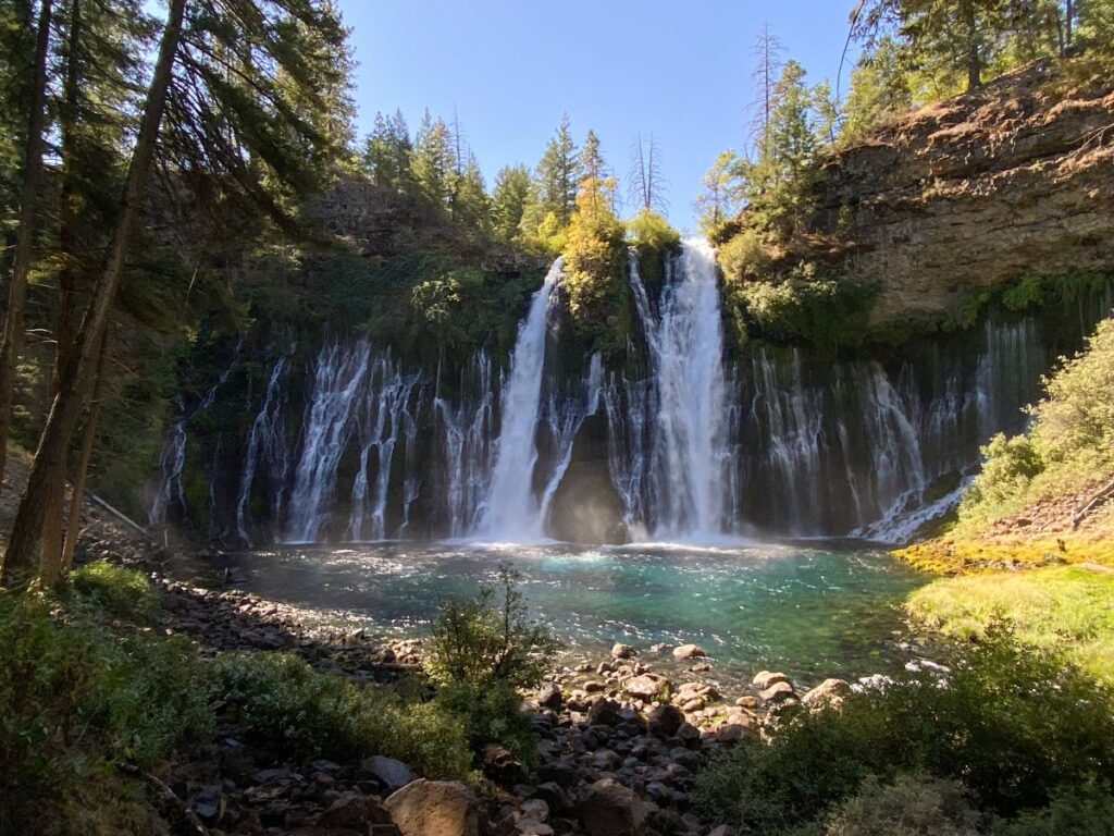
Grab lunch in the nearby small town of Burney before hitting the road back to Lassen.
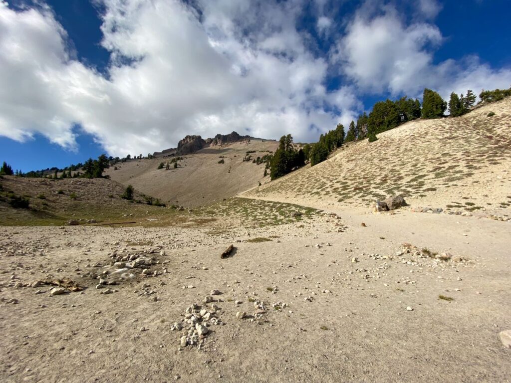
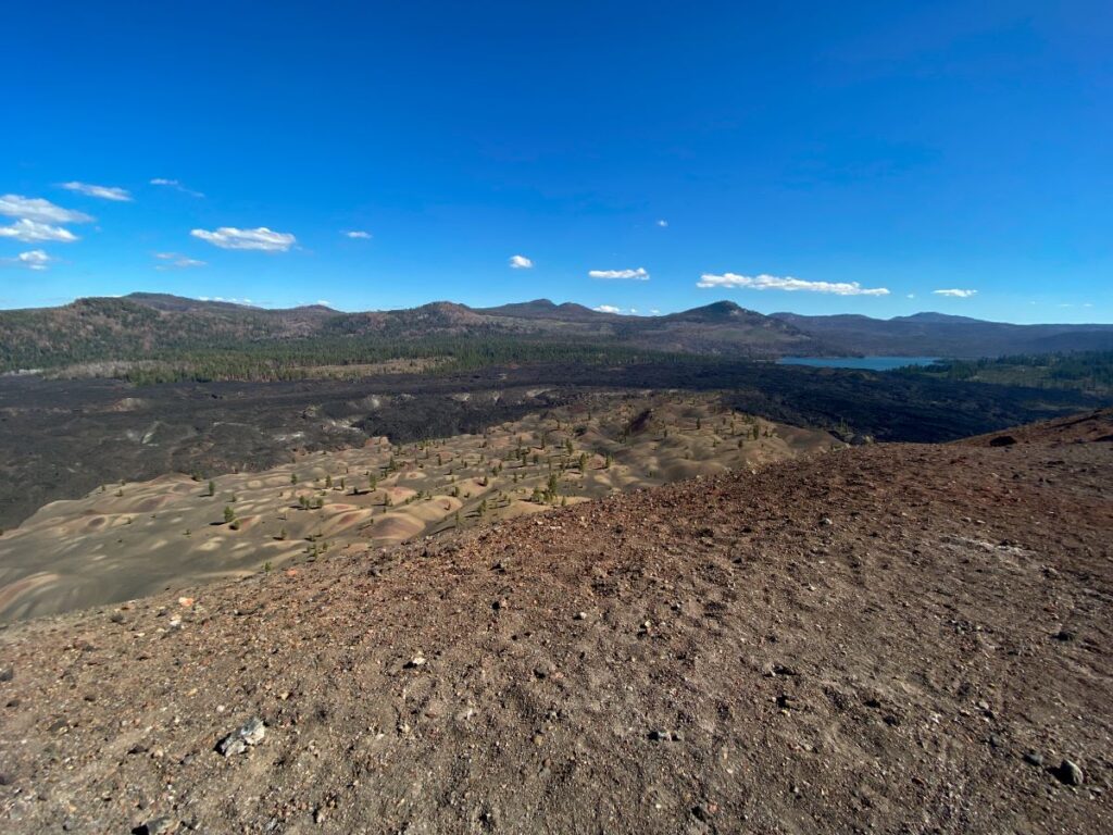
Cinder Cone Trail
The drive back to Lassen from Burney Falls conveniently passes by the Butte Lake area of the park in the northeast corner. This area is more remote and requires a 6-mile drive down a dirt road. You’ll be fine in any passenger car so don’t worry!
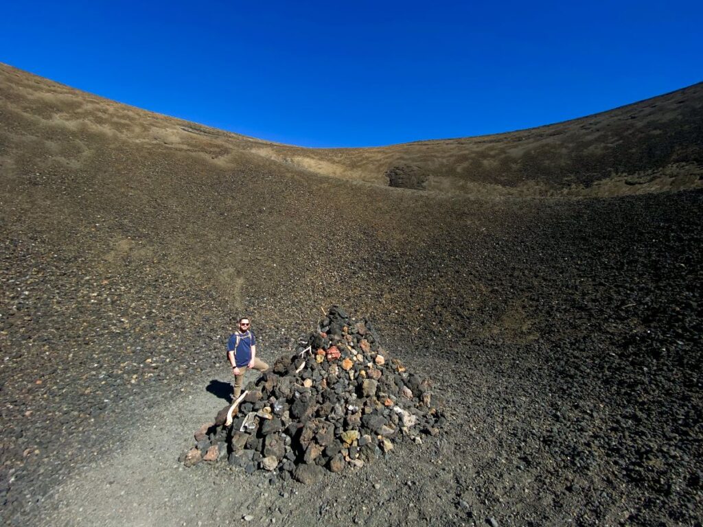
Follow the signs for the Butte Lake Campground, park your car, and get ready for a fantastic, strenuous hike up a cinder cone volcano!
Starting from the Lake Butte Campground, you’ll walk slightly uphill for about 1.5 miles along the Fantastic Lava Beds.
Once you reach the cinder cone, the fun really begins. You’ll climb over 500 feet in less than a half mile through some loose volcanic sand.
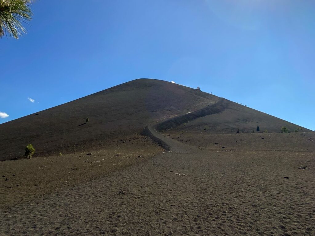
This portion of the hike is strenuous not only for the steep climb, but also due to the loose sand you’ll be climbing over. Every step forward results in a half-step back as you sink into the sand.
As you summit the cone, a fantastic view of the Lassen Peak motivates you to keep going. When you finally reach the peak, you’re rewarded with the opportunity to hike down into the cinder cone and take in the amazing views from all angles of the peak.
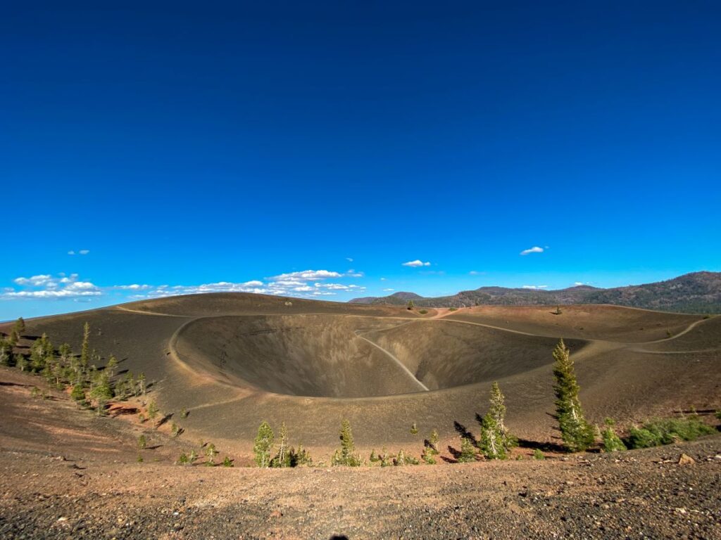
The Painted Dunes, Fantastic Lava Beds, Lassen Peak, Snag Lake, and Prospect Peak are all visible from the top. The Painted Dunes might have been the weirdest landscape I’ve ever seen.
The Cinder Cone Trail is easily one of the top 5 hikes I’ve ever done. It’s a great alternative to the Lassen Peak Trail if you’re looking for a challenging summit with panoramic views, but aren’t quite up for the 10,500-foot climb up Lassen Peak.
Day 7: Lassen Volcanic National Park to San Francisco
Total Driving Distance: 230 miles / 4.5 hours
There are multiple routes that you can take on your way back to San Francisco and the airport. Traffic can get absolutely insane in the Bay Area, so check your maps as you get closer for the quickest route.
Napa and Sonoma Valleys are a bit out of the way but doable if you want to stop at a few wineries before you arrive back in San Francisco.
This day concludes your northern California road trip. Spend the night near the airport or catch your flight home!
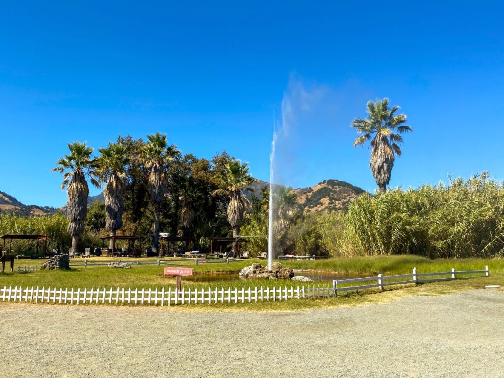
Optional Detour: Old Faithful Geyser of California
Yes, you read that right, there is an Old Faithful in California!
After visiting the real Old Faithful in Yellowstone earlier in the year, we couldn’t resist checking out the Old Faithful of California.
It’s located in Calistoga just north of Napa on privately-owned land surrounded by palm trees and mountains.
It has predictable eruptions every 30 minutes to an hour. There is a gift shop, courtyard-type seating area surrounding the geyser, and drinks and snacks for purchase.
It will cost $15/person to get in (definitely price-gouging, but hey, that’s California for ya!). Obviously, this geyser is nothing compared to the real Old Faithful, but it can be a nice spot to relax and break up your drive.
It is a bit kitschy and felt like we were literally sitting in some random person’s backyard, but hey, we can say we saw both Old Faithful’s in the same year!
If You Have More Time
If you have just 1 or 2 more days to spend on your northern California road trip, I would spend them doing more hikes in Lassen or the Redwoods. You could also spend more time exploring San Francisco or Sacramento.
If you have even more time, you can add on one or more fantastic nearby destinations. Here are a few suggestions:
- Mount Shasta: Mount Shasta is a majestic, active, stratovolcano located about 2 hours north of Lassen Volcanic National Park. Its peak sits at over 14,000 feet and has a spiritual history that dates back to the American Indian tribes that lived in the region.
- Crater Lake National Park: Crater Lake National Park is home to the deepest lake in the US at over 1900 feet! It’s located in Oregon about 4 hours from Lassen and 5 hours from Eureka.
- Lake Tahoe: Lake Tahoe is another bucket list destination only 3.5 hours from Lassen. If luxury resorts and casinos are your thing, you can experience that along with world-class hiking, boating, and skiing at North America’s largest alpine lake!
Did this post help you plan your own northern California road trip? Is there anything you would add to this itinerary? Let me know in the comments below!
-Megan
Pingback: The Ultimate Point Reyes Day Trip Itinerary - Engineer to Explore