Last Updated on December 13, 2024 by Megan Rynearson
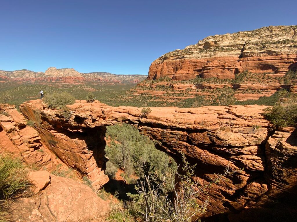
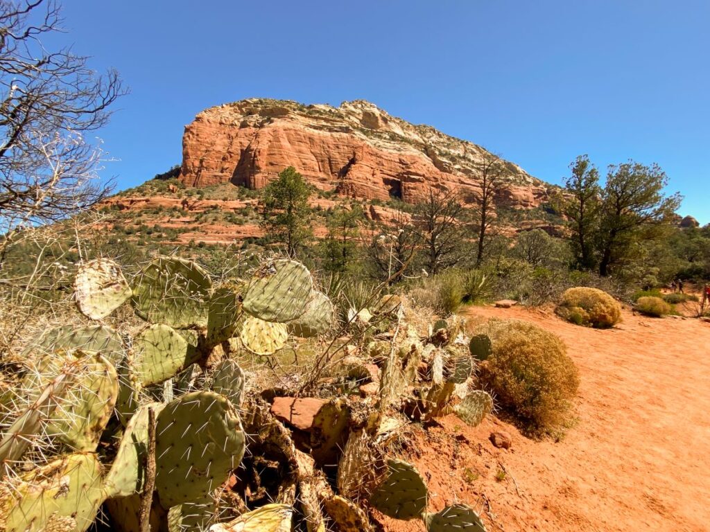
Hiking to Devil’s Bridge in Sedona is an incredible experience to add to your Arizona itinerary. The trek through gorgeous red rock scenery up to the largest natural arch in the Sedona area does not disappoint!
Devil’s Bridge is one of the most popular hikes in Arizona. It is estimated that tens of thousands of people hike this trail every year, and there can be close to 100 people at the top at any given time. This unfortunately creates some unique challenges for hiking this trail.
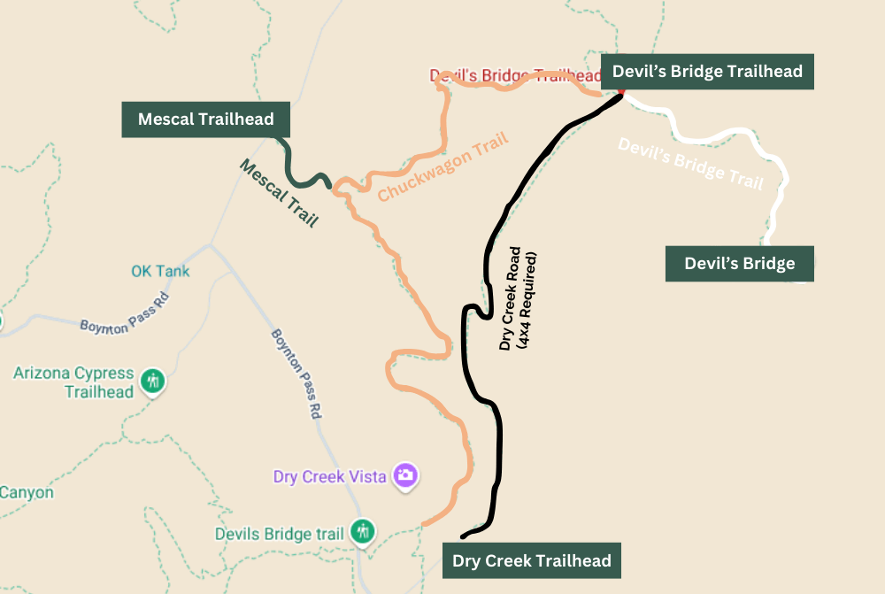
There are 4 different ways to hike to Devil’s Bridge and each one has its own pros and cons. If you want to take the shortest hiking route, you will need a high-clearance 4×4 vehicle to get to the trailhead.
Despite the crowds and parking challenges, hiking this trail is 100% worth it! This guide will walk you step by step through all 4 hiking trails to get to Devil’s Bridge, including how to get to each of the trailheads, the best route to take, parking info, photos, hiking tips, and more!
And if you’re looking for more Sedona hikes, check out my list of top 10 hikes in Sedona!
The Best Time to Hike to Devil’s Bridge
The best time to go hiking in Sedona is in the spring and fall, when temperatures aren’t too hot and the weather is nice. Unfortunately, this is also the busiest time to visit.
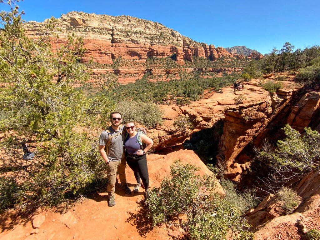
We visited in late March and tried our luck at hiking to Devil’s Bridge on a Thursday at 10 am. We found parking pretty easily at the Mescal Trailhead, but it was busy. The line to take a photo on Devil’s Bridge was about an hour long!
I suggest planning to hike to Devil’s Bridge early in the morning on a weekday if possible, especially if you’re going in the spring or fall. You’ll have an easier time finding parking and see a lot less people on the trail.
Do You Need a Red Rock Pass to Hike to Devil’s Bridge?
Yes, you will need a Red Rock pass to park at all of the trailheads close to Devil’s Bridge. Your America the Beautiful National Park Pass will also work for this hike.
There are daily, weekly, and annual Red Rock Pass options for $5, $15, and $20, respectively. You can purchase one at the kiosks located in the parking lots of some of the trails, the Sedona Visitor’s Center, or online here.
If you plan to visit more than 3 National Parks or Monuments on your trip to Arizona (or within one year), getting the America the Beautiful National Park Pass will save you money vs. paying the separate fees at each park. It costs $80 and you must order ahead of time as they will ship you a physical pass.
Related: 12 Incredible Things to Do in Page, Arizona
Sedona Shuttle Information
Since hiking in Sedona has exploded in popularity, the city started a free shuttle program to take hikers to the most popular trailheads around town.
There are 4 different lines that run from 7 am to 5:30 pm. During peak season, it runs every day. The shuttles are completely free and don’t require reservations.
You can download a map of all the shuttle locations on the Sedona Shuttle website here. For the Devil’s Bridge hike, you will want to take the blue route 11 to the Dry Creek or Mescal trailhead.
We didn’t end up needing to use the shuttle, but it can be a good option, especially during peak season when parking is tight. You shouldn’t need to use the shuttle if you plan to get to the trailhead before 8 am. Even less so if you hike on a weekday!
Devil’s Bridge Hiking Stats
Length: 3.9, 5.7, or 2 miles
Elevation gain: 528 feet
Type: out-and-back
Difficulty: moderate
Time: 2-3 hours
Trailhead location: Mescal Trailhead, Dry Creek Road, or Devil’s Bridge Trailhead (high clearance 4×4 required)
Red Rock/National Pass Required?: Yes, both accepted and required at all trailheads
Devil’s Bridge is a relatively easy hike with a short rock scramble at the end. The length of your hike will depend on which trailhead you start from. The overall elevation gain each way is roughly the same.

How to Hike to Devil’s Bridge
You have several options for hiking to Devil’s Bridge: The Mescal Trail, Dry Creek Road, The Chuckwagon Trail, or The Devil’s Bridge Trail. The different options are shown on the map and described in more detail below.
The hike is mostly easy until you get to the end where there is some moderate rock scrambling up to the top. The rock scrambling portion wasn’t too strenuous and it was pretty easy to maintain 3 points of contact while hiking. You should be okay on this trail even if you have a fear of heights.
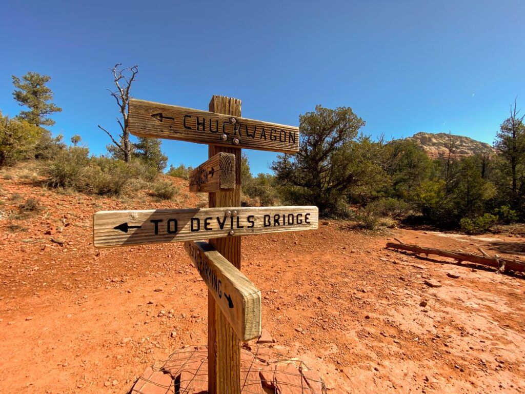
All of the trails are well marked and easy to follow.
Reserve about 2-3 hours to hike this trail, and add extra time for photos at the top!
OUR EXPERIENCE: This was actually the first hike we did in Sedona. We stopped by Sedona on our way to Flagstaff from the Phoenix airport and actually found a parking spot at the Mescal trailhead around 10 am on a Thursday in late March. The line for photos at Devil’s Bridge was insanely long, so we took a photo off to the side instead.
Hike to Devil’s Bridge Via Mescal Trail
3.9 miles | no 4×4 required | AllTrails Link
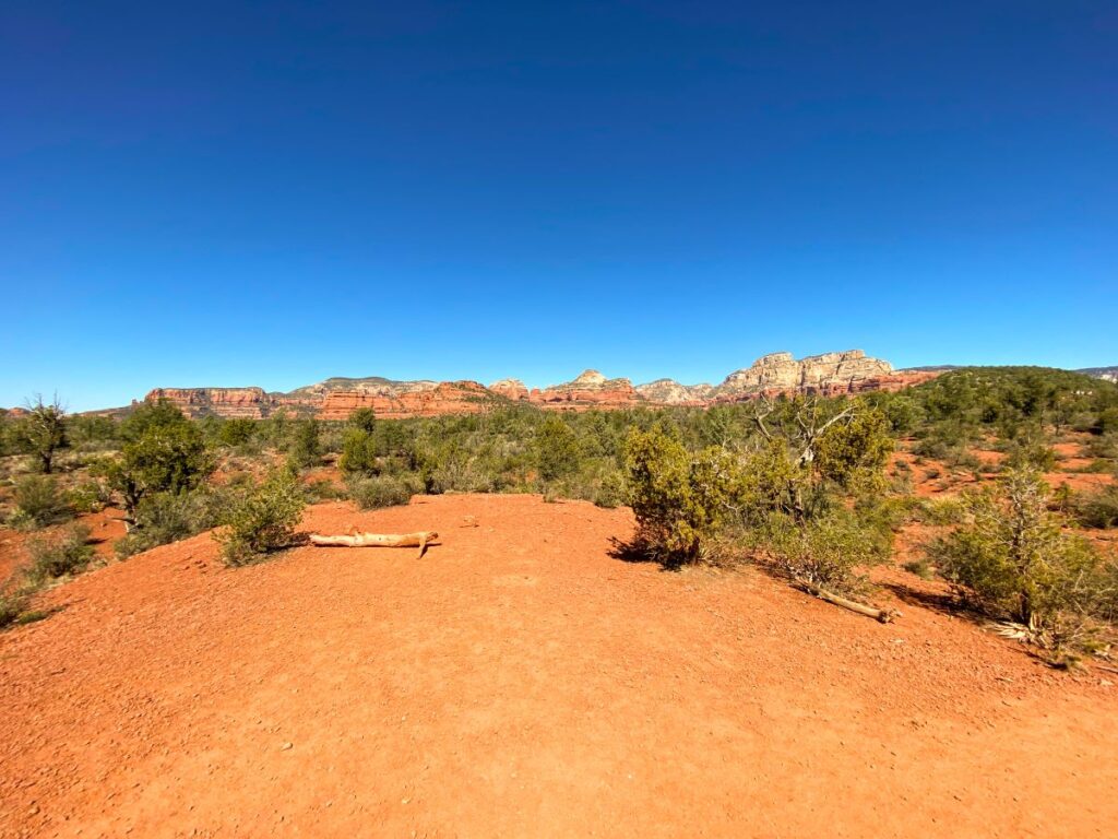
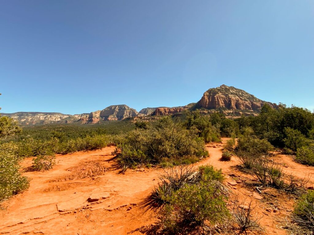
This is the way we did the hike to Devil’s Bridge. The scenery on this trail is great and the hike isn’t too long. This is the most direct route to hike from if you don’t have a high-clearance 4×4.
Park or take the Sedona Shuttle to the Mescal Trailhead off of Long Canyon Road. There are about 40 parking spaces here, so I suggest arriving early to ensure you get a space.
You’ll hike a short distance on the Mescal Trail until you reach the Chuckwagon Trail. Turn left onto the Chuckwagon Trail and follow it until you reach the Devil’s Bridge Trail. Go straight and follow the signs for Devil’s Bridge. Your round-trip hike this way will be 3.9 miles.
Hike to Devil’s Bridge Via Dry Creek Road
3.9 miles | no 4×4 required | AllTrails Link
Hiking to Devil’s Bridge this way requires you to start at the Dry Creek Trailhead and walk down Dry Creek Road. You can take the Sedona Shuttle here or drive and park at the trailhead.
From here, it is a straight shot down Dry Creek Road and then a right turn onto the Devil’s Bridge Trail at the intersection. Your round-trip hike this way is about 3.9 miles.
I don’t recommend hiking this way because you’ll be walking down an un-scenic, dusty, dirt road until you reach the Devil’s Bridge Trail. The scenery is much better on the Mescal and Chuckwagon Trails, and the distance is the same via the Mescal Trail.
Be aware that Dry Creek Road is a popular 4×4 and mountain biking road, so look out for cars and bikes if you hike this way.
Hike to Devil’s Bridge Via Chuckwagon Trail
5.7 miles | no 4×4 required | AllTrails Link
You’ll start your hike this way by parking or taking the Sedona Shuttle to the Dry Creek Trailhead. Instead of walking down Dry Creek Road, you’ll take a slightly longer, more scenic route on the Chuckwagon Trail.
Follow the Chuckwagon Trail (always keep right) until it intersects with the Devil’s Bridge Trail and then go straight. You will pass the Mescal Trail intersection about halfway in, so remember to keep right and follow the signs for Devil’s Bridge. Your round-trip hike this way will be 5.7 miles.
This route is longer than if you had walked straight down Dry Creek Road, but the scenery is so much better. Since there isn’t a huge elevation gain on the Chuckwagon Trail, I think the extra distance is worth it vs. hiking Dry Creek Road.
You could also take the Chuckwagon Trail to Devil’s Bridge and then walk Dry Creek Road on your way back for a slightly shorter hike.
Hike to Devil’s Bridge Via Devil’s Bridge Trail
2 miles | 4×4 required
Hiking to Devil’s Bridge this way is the shortest and most direct route, but it does require a high-clearance 4×4 vehicle to get to the trailhead. Instead of parking at the Dry Creek Road lot, you’ll drive down Dry Creek Road and park at the Devil’s Bridge Trailhead lot. There are quite a few large rocks on the road that you’ll need to clear, so I would not attempt this in any regular car (and definitely not in a rental car).
This lot is extremely small and only has room for just a handful of vehicles. It was full when we passed through around 11 am on a Thursday. The Sedona Shuttle does not stop directly at the Devil’s Bridge Trailhead.
Once you get to the trailhead, it’s a straight shot to Devil’s Bridge. Follow the signs and the crowds and you will be there in about 30 minutes. Your round-trip hike this way will be about 2 miles.
What is the Best Way to Hike to Devil’s Bridge?
If you have a high-clearance 4×4 and you want the shortest hiking route, the best way to hike to Devil’s Bridge is directly from the Devil’s Bridge Trailhead.
If you don’t have a 4×4, the best way to hike to Devil’s Bridge is from the Mescal Trail. This is the shortest hiking route if you do not have a 4×4. We quite enjoyed the scenery from the Mescal and Chuckwagon Trails and it doesn’t add significant elevation gain, so I would definitely recommend hiking this way.
The only way I WOULD NOT recommend hiking to Devil’s Bridge is walking directly down Dry Creek Road. If you end up parking in this lot, I suggest taking the Chuckwagon Trail for better scenery. Yes, the hike is longer this way, but it is worth it. You could even take the Chuckwagon Trail to Devil’s Bridge and then walk Dry Creek Road on your way back for a slightly shorter route.
Tips for Hiking to Devil’s Bridge
Start early or go late, especially if you want a photo of you standing on the bridge. This is an extremely popular trail and the line for photos can be over an hour long (no, I am not exaggerating). If this is important to you and/or you want to minimize parking stress, get to the trailhead by 8 am on a weekday if you can.
Be prepared to wait in line for a photo of you standing on the bridge. Almost everyone does this hike just for the photo of them standing on the bridge, and they will go to great lengths to get it. A line will form for photos, so bring your patience and enjoy chatting with other hikers in line while you wait.
Wear sun protection. With very few exceptions, hiking in Arizona is out in full sun and the Devil’s Bridge Trail is no exception. Bring sunscreen, hats, sunglasses, and plenty of water on your hikes.
Be flexible. If the trailhead parking lot is full, try another trail, take the Sedona Shuttle, or come back later. There were multiple hikes we tried to do but couldn’t find parking, so we had to change our plans. It’s the nature of the beast in popular destinations like Sedona!
Related: 10 Amazing Hikes in Sedona, Arizona
More Things to Do in Sedona
There is no shortage of amazing hikes to do in Sedona! Check out the 10 best hikes in Sedona and add one or more of these trails to your itinerary:
- Birthing Cave
- Courthouse Butte & Bell Rock Loop
- Bell Rock Climb
- Cathedral Rock Climb
- Airport Loop
- Soldier Pass
I hope this post helped you plan your hike to Devil’s Bridge! A little bit of thought and planning goes a long way when visiting popular desinations like Sedona.
Which trail do you plan to take on your hike to Devil’s Bridge? Let me know in the comments below!
-Megan
More Information on Arizona
ARIZONA ROAD TRIP: This 9-day northern Arizona road trip that starts and ends in Phoenix takes you to Sedona, The Grand Canyon, Petrified Forest National Park, Flagstaff, Monument Valley, Antelope Canyon, Horseshoe Bend, and more!
THE GRAND CANYON: One of the 7 wonders of the world, a trip to the Grand Canyon is a must. Check out my ultimate guide to visiting the Grand Canyon South Rim or learn how to visit the Grand Canyon in the winter.
FLAGSTAFF, AZ: Located in the heart of northern Arizona, Flagstaff is a neat little town that makes a great home base for exploring the nearby attractions. There are 3 incredible National Monuments within an hour drive, Lowell Observatory, and plenty of other things to do. Make sure to check out the brewery trail while you’re in town!
PAGE, AZ: Page makes a perfect long weekend destination and is packed with famous attractions like Horseshoe Bend, Antelope Canyon, Lake Powell, and more. Check out the top 12 things to do in Page to help you plan your visit!
PETRIFIED FOREST NATIONAL PARK: Petrified Forest is a highly underrated National Park that you can visit in one day with fascinating geology and unreal scenery. It’s a 2.5-hour drive from Sedona and makes a great road trip stop. Check out my guide to Petrified Forest here.
SAGUARO NATIONAL PARK: Located in Tucson, walk among the nation’s largest cacti. It is a 3.5 hour drive south from Sedona.
MONUMENT VALLEY: Incredible scenic drive full of sandstone buttes where many famous movies were filmed. It’s located 3 hours northeast of Sedona and will be on your way to Moab, Utah. Check out my guide to Monument Valley for more details on how to visit!